 |
Villages of |
Greasby |
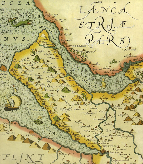
At the start of the 20th Century, Greasby was an agricultural village with a fortnightly cattle market, and a population of 290. Today, Greasby is a ‘commuter suburb’ with almost 10,000 inhabitants. The dramatic transformation is a comparatively recent phenomenon and stems largely from the introduction of public motor transport after the first world war, and the decentralisation of population in the Merseyside region.
Many families, and newly-married couples, were attracted to the semi-rural atmosphere of the area. However, despite the campaigning of local protest groups, Greasby has become ‘merely another segment of the ever-spreading suburbia generated by the needs for housing of Liverpool and Birkenhead’.
 At the time of the Norman Conquest, Gravesberie was held by a certain Dunning who may have been a ‘greave’ or high official of the earls of Mercia, and who also held Storeton. At one time it was thought that the place name of Gravesberie derived from the Anglo-Saxon graf or grove, and so referring to the woodland that once covered the area. A more probable derivation is from the words graef and byrig signifying a fortified house with a pit or trench.
Sometime before the Doomsday survey of 1086, the manor was given to Nigel de Burci, and the value was less than in 1066. Prior to 1093 the Greasby tithes, along with those of Storeton, were given to High Lupus, first Earl of Chester, to the Abbey of St. Werburgh in Chester. Subsequently, Robert de Rullos conferred the entire township on the abbey and the charter was confirmed by his sons, Richard and Robert, in 1284-85.
After the dissolution of St. Werburgh’s Abbey, in 1540, Greasby was granted to the Dean and Chapter of Chester Cathedral. In 1556 the estates passed to Sir Richard Cotton, privy councillor of the king’s household, and his son George. In the seventeenth-century, Greasby was held by Edward Glegg of Irby (1657).
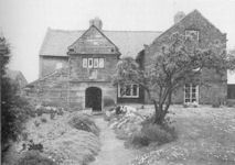
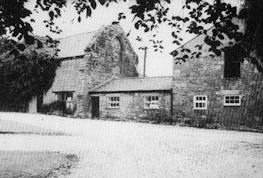
Greasby still possesses some old buildings, and most of these are near the old village crossroads. Few retain period features. The Old Hall lies on the eastern side of Pump Lane and is almost hidden by outbuildings. Over the porch is a weathered coat of arms and the old oak entrance door still exists. The house has been much altered over the centuries, although oak beams and a large fireplace remain in an attic room. The eastern wing was probably added in the late seventeenth-century.
The Hall is said to have belonged to the monks of St. Werburgh, at least until the Dissolution. Recesses in the porch may have been used for monastic alms. A priest hole in the hollow stone wall to the right of the porch, (now blocked up), suggests that the house was used as a hiding place for Catholic recusants in the seventeenth-century.
Most people know Manor Farm as a Restaurant. The farmhouse and outbuildings date from the late seventeenth-century, and the granary bears a 1695 date stone.
School Farm, in Mill Lane, formed part of the estate of William Glegg, and was given by him to Calday Grange Grammar School in 1636.
Penny Lane, near the centre of the old village, takes its name from the old village pump which once stood near the junction with Frankby Road. It is often thought that this lane might be part of a ‘Roman’ road which extended from Chester, northward to Meols. ‘Operation Pump Lane’ in 1980-81 revealed no Romans construction although excavations by Peter France in 1964, south-west of Rigby Drive, uncovered forty large red sandstone kerbstones. However as W. Thompson Watkin pointed out in 1886…”the whole of the evidence as to a road from Meols to Chester is most unsatisfactory”.
Frankby |
Frankby is a village where the horse population almost outnumbers the humans. The place manages to retain the ‘rural’ atmosphere and unhurried calm which near neighbour Greasby has now lost. A report published in 1973 by the Cheshire County Council Planning Department, noted that Frankby was unique amongst Cheshire villages in that the majority of inhabitants still gained employment from the surrounding farmland. By 1983, Frankby possessed only one working farm.
Yew Tree Farm, which dated back to 1710, was a red brick with stone quoins; the attractive brick work has now been painted over. The farmhouse which is now a privately own house is of two storeys with attics. The early nineteenth-century windows show alteration, but has been described as being in good condition with a pleasant setting. The farm also contains brick and sandstone outbuildings; one barn (Elderberry Barn) now converted into a residential property.
 At the time of Doomsday, Frankby was probably that portion of Calders, or Caldy, held by a Frenchmen – hence the name of Frenchman’s homestead. From the early twelfth-century, the manor was held by the Orreby family (who also held Willaston) and later it passed to the Ardernes and the Bold family of Lancashire, who held it from 1432-1612. After this time the holdings were sold to tenants, the principal of whom was Peter Day (who died in June 1641). Later transfers again were just as rapid as previously, until John Robin of West Kirby.Esq., bought the estate in 1818 and became lord of the manor. The manor gradually became divided among many freeholders. (Sulley 1889) In 1847 the manor and township of Frankby was 433 acres in extent and had 125 in habitants all engaged in agricultural pursuits. (Mortimer, 1847). ‘There are three or four large and tolerably respectable houses in the village, which otherwise presents the ordinary appearance of the hamlets of this part of the hundred. The greater of the land is very inferior. (Mortimer, 1847).
The historical interest of the village lies in the old farm buildings clustered around the ‘pocket handkerchief’ village green. The village itself ‘is surrounded by one of the best preserved open field enclosure patterns that remain in the district’.
Don’t be fooled by the impressive looking ‘Tudor’ mansion called Hill Bank. Although built on the site of an ancient tithe-barn at the summit of Frankby Hill, the building is actually ‘Bidston Court’ – a pseudo-Elizabethan edifice moved wholesale to this site from Noctorum and re-erected in 1929-31.
Irby |
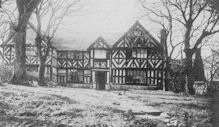 In his book The Wirral Peninsula, published in 1955, Norman Ellison commented that ‘Irby has lost its old-world charm and has become a suburb of Birkenhead’. Irby Hall, therefore, looks somewhat incongruous. The present building is of early seventeenth-century origin and occupies the site of a manor house of the monks of St. Werburgh. Three sides of a moat are still visible.
Ormerod (1819) described the Hall as a ‘plaster and timber building’ but by 1888 the structure was ‘rapidly falling into decay’. It was then restored but the half-timbering above the ground floor was not totally replaced. The remaining three sides are of stone, and a massive chimney-stack remains on the north side.
Irby Farm, at the village crossroads, was once the residence of an old Irby family, the balls. Their tenancy of this farm can be traced back at least to the reign of Henry VI (1422-61). Various house plates on the outbuildings and main farmhouse refer to reconstruction work in the seventeenth and early eighteenth-century.
Storeton |
 In early times Storeton may have been a place of some strategic importance, the ‘hub’ of a network of ancient roads and in sight of the surrounding land and sea coast. The best known example of such an old track is ‘Roman Road’, sometimes referred to as ‘Monks’ Stepping Stones’. and stretching from Storeton to Woodchurch. This is almost certainly mediaeval in origin, a simple packhorse track stone-ribbed so that the locals could negotiate the muddy fields.
Storeton Hill has been called ‘one of the most picturesque features of Wirral’ – a deep, solid edge of fine white stone which has resulted from the faulting of the overlying strata of new red sandstone. The extensive quarries are now filled in and actually lie in the township of Higher Bebington. They once supplied fine quality stone to local builders. Several inscribed and sculptured Roman stones, now in the Grosvenor Museum, Chester, are thought to have come from Storeton and the stone was used at Bebington parish church, Birkenhead Priory and Storeton Hall.
At the time of the Doomsday survey, Storeton formed part of the estates of Nigel de Burci, a retainer of the baron of Halton. About the year 1120 Storeton, with Puddington and the bailiwick (i.e. the area under official jurisdiction) of the forest of Wirral, was presented by the third Earl of Chester to his steward Alan Sylvester.
The only daughter of Alan Sylvester’s son, Ralph, married with Alexander, the tutor of the sixth Earl of Chester, and their daughter, Agnes, married Sir Thomas Bamville in 1315. Bamville’s son and heir, Sir Philip the elder, had no issue so the estates were divided between Bamville’s three daughters, the eldest of whom married Sir William Stanley. His great grandson was the immediate ancestor of a long and distinguished line of Stanleys.
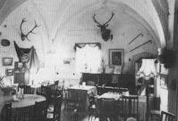
Storeton Hall, although now incorporated, and almost lost, amidst a large working farm, was once an important private residence. It was the seat of the Sylvesters, the foresters of Wirral under the Earl of Chester, then the home of the Bamville’s, and, in 1282, the Stanleys who held it until 1848.
The mediaeval Hall dates from the mid fourteenth-century and may have ceased to be the principal seat of the Stanleys after the building of Hooton Hall (1487-89) for Sir William Stanley. It may have been abandoned as a residence after the building of the farmhouse to the north which incorporates a blocked up Jacobean window. Although the Hall was neither crenellated nor moated, the doors and walls were unusually thick and may have been designed with defence in mind.There was originally a central hall on the west side, of which only the inside face of the eastern wall remains. This is now the outside face of farm buildings. A great entrance door remains at the south end and a central buttress suggests that there was a central hearth.
At the southern end of the hall there was once a doorway which led to the kitchen and butteries. At the north east end of the hall an arched doorway (now a storeroom entrance) led to a staircase tower. Mr E.W Cox (1897) concluded that, in the absence of corbels and sockets in the existing hall walls for the roof timbers, the hall roof ‘was of cradle form, of the early type…’. The roof of the solar and chapel was probably similar.
The great chamber and solar, or upper living room, and the chapel with a room over it, are the best preserved parts of Storeton Hall at the northern end. The great chamber was divided into modern offices and the springing (where the arch rises from its support) of the gables remains.
In the solar, to the west, there is a high pointed gable window of two lights which is now blocked up. The entrance to this room is by a small door from the chamber above the chapel although, originally, it was entered by the staircase tower at the south east corner.
Both the chamber and the solar once possessed fireplaces in the centre of the northern wall; of the latter, a moulded hood can still be traced in the wall.
The chapel is a small room to the east of the north wing. The external facings and tracery of the windows - if these existed - have been destroyed, and blocked by an external staircase of seventeenth-century date. In 1371 the Bishop of Lichfield gave authority to William Stanley to establish an oratory (i.e. a place for private worship) in Storeton.
The remains of Storeton Hall are now almost forgotten; the growth of ivy on the west side can only weaken this once formidable structure and all the historic rooms are now neglected.
Brimstage |
A short distance from the busy Clatterbridge exit of the mid-Wirral motorway, lie a group of straggling cottages scattered around a village green. Brimstage - in mediaeval times Branstath - was once part of Bromborough and subsequently, in 1868, united with Raby to the parish of Thornton Hough. It was the original settlement of an old Cheshire family, the Domvilles, whose eldest line is now represented by the Earl of Shrewsbury.
The first of this family occurs in the reign of Edward III (1327-77) when they also held Oxton, Raby, and part of Mobberley in East Cheshire. In 1397 the manor estates - which now included Thingwall - passed in marriage with Margery Domville, second daughter and heiress of John Domville the younger, to Sir Hugh Hulse of Raby.
The son of Sir Hugh, Thomas, inherited in addition to the Brimstage estates, part of the manor of Little Neston, the hamlet of Hargrave and land in Thornton. After the death of Thomas in August 1432 William Troutbeck acquired all the Domville lands, as a result of the minority of Margery Hulse to whom he married his son.
The estate passed to Sir John Troutbeck of Dunham who was slain at the Battle of Blore-Heath in 1460. As late as 1877 Brimstage and Raby were subject to a Court Leet (a local manorial court dealing with petty offences) held under the Earl of Shrewsbury.
The Domvilles were a family of some standing in the Middle Ages. In 1275 the inquisition of the death of Robert de Montalt (the steward of Chester and lord of Brimstage, who died in 1162) showed that Sir Roger Domville held land in Brimstage and Oxton. He was a member of the county court and sat on many juries, in 1277, 1281, 1284 and 1289.
In 1334 John Domville, possibly the grandson of Sir Roger, was in possession of Brimstage and Oxton but let other lands to trustees, notably in Thingwall and Barnston. In January 1340 he was appointed warden of the property of Vale Royal Abbey, founded by Edward I for the Cisterian monks, south-west of Northwich.
John Domville and his family were frequently in trouble with the courts. In the trailbaston court of 1353, John Domville and Richard Hough - listed as sergeants of the peace - were accused of hiding treasure trove which he found at Gayton by one of Domville's tenants. They failed to hand it over to the Earl of Chester.
 It was further claimed that Domville, Hough and Robert Poole, together with about thirty others, hunted upon many occasions with greyhounds in the forest of Wirral. They threatened the Abbot of Basingwerk's lay-brother at Calday grange and forced him to give them food and drink. The goods, corn and chattels belonging to the Abbot were destroyed by the men's violence, and his horses, greyhounds and dogs were threatened.
In February 1398 Hugh Hulse and his wife, Margery, obtained to build an oratory at Brimstage. This private chapel is traditionally thought to be the vaulted room at the base of the mediaeval tower. This interpretation arises from the supposition that because a room is vaulted it was used for religious purposes. There is no real evidence that this was the case at Brimstage and the vaulted tower storey is typical of the mediaeval tower house.
In the south-east corner of this room at Brimstage is a roughly cut corbel, said to be an early representation of the 'Cheshire Cat'. The figure looks more like a fierce Scottish Fold then a 'Cheshire', although the mason may originally have intended to represent the red lion rampant - the Domville coat of arms. On one of the ceiling bosses there are three entwined fishes, the arms of the Troutbeck family who inherited the Brimstage estates in 1432.
Sadly, the walls of this chamber have been whitewashed. These days the Hall has been converted to house craft shops and businesses in its main courtyard.
The central portion of Brimstage Hall, on a north-south axle, appears to be of sixteenth-century origin; the north part is a later addition. One authority has suggested that the Hall 'has every appearance of having been a tower house, ie.a compactly olanned dwelling of the pele-tower type'.
The tower at one time consisted of three storeys connected by a flight of stairs winding round a central pillar. The rectangular turret at the south-est corner contains garderobes (toilets) and rises to the full three storeys. At the summit there are machicolations, or holes in the floor to drop missiles through. This projecting roof, supported on massive corbels, may have been for beacon fires as part of an ancient signalling network from North Wales to Storeton Hill.
The site of the Hall was surrounded by a moat which is still fairly visible on three sides. In part of the garden, near to the tower, several bodies have been found laid out in such a way to suggest that this area may have been once used as a cemetary.
Finds made in the 1890s during the building of the house, close to the eastern entrance gate, included human bones and carved stones. E.W Cox, in his book 'Leaves From An Antiquary's', said in 1895 - "The discovery of graves, the character of the tracery (of the fragments), and the finding of a stoup suggest a separate ecclesiastical building, standing with its graveyard to the east of the hall"
Source
The Search For Old Wirral - David Randall
The Wirral Peninsula - Norman Ellison
A Perambulation Of The Hundred Of Wirral - Harold Edgar Young
Digital discoveries
- Non Gamstop Casinos
- Casino Not On Gamstop
- UK Casinos Not On Gamstop
- Non Gamstop Casinos UK
- Sites Not On Gamstop
- Sites Not On Gamstop
- Casinos Not On Gamstop
- Casinos Not On Gamstop
- Casinos Not On Gamstop
- Non Gamstop Casino UK
- Casinos Not On Gamstop
- Non Gamstop Casino
- UK Online Casinos Not On Gamstop
- UK Online Casinos Not On Gamstop
- Non Gamstop Casinos
- Casino Sites Not On Gamstop
- Casinos Not On Gamstop
- Casinos Not On Gamstop
- Best Betting Sites
- Casinos Not On Gamstop
- Gambling Sites Not On Gamstop
- Betting Sites That Are Not On Gamstop
- Non Gamstop Casinos UK
- UK Online Casinos Not On Gamstop