Wallasey From
1831 to 1851
Before considering the development in Wallasey between 1831 to 1851 it is worth just studying briefly the conditions of the Wirral as a whole in 1831. The population density of the Wirral Township had changed rapidly in 1801 and 1831 which resulted in a change in the distribution of the population. In general, the greater part of the Wirral in 1831 had retained its agricultural character with a scanty population. Neston and Parkgate had a very slight increase and still maintained its dominance in the western or Deeside portion but in contrast it had lost its outstanding importance in the Wirral as a whole. The north-east corner comprising Birkenhead and Wallasey was easily the most densely peopled area. Here, the densities in the townships passing from north to south had increased as follows :-
| |
1801 |
1831 |
person per 100 acres |
| Liscard |
23 |
107 |
| Poulton-cum-Seacombe |
21 |
146 |
| Birkenhead |
12 |
287 |
| Tranmere |
33 |
109 |
The main reason for these increases is to be found in the growth of Liverpool and the beginning of the absorption of the Merseyside part of the Wirral into its sphere of influence, which was to become more and more pronounced as the century advanced. This resulted largely from the development of better and safer ferry services across the river and in connection with this second important factor was becoming more evident in the case of Birkenhead. This factor was the growth of better land communications especially in regard to coach services on the Birkenhead-Chester Road and the through route to Liverpool to London, via Birkenhead and Chester. Wallasey, however, in regard to land communications still remained largely isolated.
Growth of Population In Wallasey, 1831-1851 |
| Year |
Wallasey
Township |
Liscard Township |
Poulton-cum-Seacombe |
Parish of Wallasey |
| 1801 |
274 |
211 |
178 |
663 |
| 1811 |
440 |
289 |
214 |
943 |
| 1821 |
444 |
345 |
380 |
1169 |
| 1831 |
558 |
967 |
1212 |
2737 |
| 1841 |
942 |
2872 |
2446 |
6261 |
| 1851 |
1195 |
4100 |
3044 |
8339 |
The figures shown above from the Census Reports illustrate clearly the changes in Wallasey to which reference has already been made. Up to 1831 there had been a certain amount of increase, from 663 to 2737, which was felt mainly in the Townships of Poulton-cum-Seacombe and Liscard, but it is in the next decade that the increase becomes most marked. In contrast to the increase of 2064 in the first 30 years of the century the next two decades show an increase 3524 and 2078 respectively. The main increases were in the two Townships bordering the Mersey and Wallasey Township showed a much lower increase. In this period then there is the beginning of the growth of modern Wallasey and its emergence from the almost mediaeval conditions that prevailed at the beginning of the century.
The chief reasons for this remarkable increase in population can be summarised as follows :-
a.The attraction of the area as a residential district in close proximity to Liverpool;
b.The establishment of new and better ferries;
c.The development of New Brighton as a sea-side resort;
d.The establishment of docks and attendant industries in the southern part of the region, bordering Wallasey Pool.
These factors are almost identical with those accounting for the even more marked growth of Birkenhead in the same period (1831: 2,569, 1841: 8,223, 1851: 24,285).
(a) The attraction of Wallasey as a residential area in close proximity to Liverpool was very strong. Liverpool, in the immediate vicinity of the docks and commercial centre, was becoming overcrowded and people were being forced further afield. Consequently, Wallasey with its open, rural character and sea-side position appealed strongly to the Liverpool merchants. Until about 1830, however, the absence if adequate ferry facilities for crossing the river had made it well nigh impossible for those wishes to be gratified. After that date the position was radically changed.
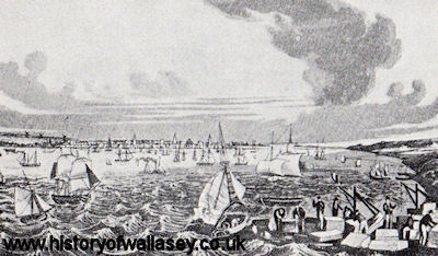
(b) The Growth of The Ferries. At the beginning of the century the only ferry of any importance was the primitive one with its small sailing or rowing boats in Seacombe. Probably another existed between Liverpool and the Magazines but this would almost wholly be used by those who had business with the ships laying off the Magazines in the "Gutter" (in a Liverpool Directory of 1821 states that sail boats were constantly plying between Liverpool and the Magazines. This persisted in diminishing importance until about 1846).
Seacombe Ferry. The 1814 Enclosure Act, refers to the rights of Richard Smith as Lord of the Manor of Poulton-cum-Seacombe in respect of his ancient ferry at Seacombe. Following upon litigation in 1816-1817 between Richard Smith and the Rev. James Mainwaring over this ferry which was settled in favour of the former, he leased it to Thomas Parry who ran it in connection with Parry's Seacombe Hotel, a popular place of entertainment and refreshment which 'obtained a high reputation among its numerous visitors, and the gourmands of Liverpool.' Even so, its influence as a factor in the development of residential Wallasey was very limited as long as sailing vessels were in use with their slow and irregular services dependent largely upon the weather. In 1829, however, steam boats were plying every hour from Liverpool and the scene was set for further improvements in 1835 when a new stone pier was constructed by Mr Parry, and a few years later (prior to 1843) when a new floating landing stage was placed in position. In 1843 the fare across was three-pence. Meanwhile, new ferries had been established, again by private enterprise, at Egremont and New Brighton.
Egremont Ferry. Mention has already been made of the dispute in 1816-1817 between Richard Smith and James Mainwaring over Seacombe Ferry. Apparently, a little later a further dispute arose between Mr Parry and Sir John Tobin who had by this time purchased a share in the Manor of Wallasey. It is very probable that from this quarrel resulted the establishment of Egremont Ferry at the southern limit of Liscard Township by the joint efforts of Sir John Tobin and Captain John Askew in 1829-30. The latter gentleman coming from Cumbria named his house 'Egremont' after his native town, and gradually the settlement that grew up around his house and ferry acquired a similar name. As at Seacombe, a fashionable hotel was established in connection with the Ferry. Subsequently, various changes in ownership took place until 1850 when both Egremont and New Brighton Ferries were owned by Mr Edward Warburton Coulbourn who managed them until 1861, when both Ferries were purchased by the Wallasey Local Board under the Improvement Acts of 1845, 1858 and 1861.
 |
Building of first Egremont Ferry, c1828 |
|
The original Egremont Ferry, pictured c1860 |
New Brighton Ferry. In the meantime further private enterprise had resulted in the construction of New Brighton Ferry in relation to the development of the northern part of Liscard Township as a fashionable sea-side resort. It will be remembered that the Enclosure Award of 1823 had resulted in the division of Liscard Common to a number of plots of land of which the greater part had gone to John Penkett, Lord of Liscard Manor. This land in turn was sold in 1830, to James Atherton, a retired Liverpool merchant interested in building and land speculation, together with part of the land allotted to Sarah Strong. All these lands, totalling approximately 163 acres appear, according to the 1841 Map of Wallasey, to have been shared by James Atherton and his son-in-law, William Rowson of Prescot.
 |
New Brighton Ferry, c1835 |
Together they planned to lay out this expense of heathland and sandhills as the future watering place of the north of England, to be called New Brighton in distinction to the older established sea-side resort of the South Coast. The attractions of the future New Brighton were set forth convincingly in the following prospectus which reads in part somewhat similarly to the growing descriptions of many of mid-20th Century Sea-Side Resort Illustrated Guides.
'As New Brighton is likely to become a favourite and fashionable Watering Place, several Gentlemen have proposed to erect there a handsome hotel, and a convenient Dock and Ferry to be called 'The Royal Light House Hotel and Ferry' and to establish a communication by Stena Packets between that place and Liverpool.
The expense of this undertaking is established at £12,000, and it is intended to raise this sum in shares of £100 such, to be placed under the management of a Committees to be chosen annually or otherwise by the subscribers.
To persons inclined to take shares this will be an eligible investment, as it holds out a prospect of an annual return of at least 20 per cent, an expectation well grounded upon its many and various advantages.
New Brighton is situated at the Rock Point, three miles division from Liverpool, and from its elevated situation commands from all points the most interesting and extensive views. The Welch Mountains, the Orme's heads and the Isle of Man are all distinctly visible, whilst its more immediate prospect embraces the opposite shares of Crosby and Bootle, the Docks and Port of Liverpool, and the furtile County of Chester.
As a Bathing Place it has peculiar advantages not only from its being the nearest point to the open sea, but it also possesses the most beautiful beach.
The sands are hard and clean, free from and, gravel or quicksands, they are many miles in extent and cannot be equalled for the purpose of exercise, whether in carriages, on foot, or on horseback.
As the tide never recedes more than 200 yards from the land, it prevents those disagreeable exhalations so common on other shores, whilst it renders bathing safe and practicable at all hours. New Brighton also possesses a more interesting sea view then any other watering place can boast, being constantly enlivened by the passaging of vessels to and from the rich and flourishing Port of Liverpool, in many instances approaching so near as to admit of persons on the shore conversing with those on board.
The proprietors intend to avail themselves of the natural advantages afforded by the undulations of the ground to erect all villas on such sites that one shall not intercept the view of another, but that all shall enjoy the same beauty and extent of prospect. Among its other advantages may be enumerated the
salubrity of the air, the certain supply of purest spring water, the aspect of all the rooms fronting the sea, enjoying the refreshing breeze, and sheltered from the oppressive heat of the afternoon's sun, while its proximity to Liverpool, together with the certainty and safety of the Steam Navigation must lend to render New Brighton a most agreeable and desirable place of resort to the Nobility and Gentry of all the neighbouring Counties.
It is intended to erect a Church, Market Place, Shops and Buildings that will include a Reading Room, Baths, Billiard Room, Post Office, etc, etc, and indeed nothing will be left undone to make it a most attractive and fashionable Watering Place.
Under such circumstances the Hotel and Ferry must combine great advantages, strangers will prefer stopping here, as they can at once step into any Packet without any inconvenience, and the Steam of Vessels or affording assistance to ships in distress.
The Grounds are now laying out in such a manner as it is hoped will command admiration. The public are referred to the Plans, and invited to view the different sites for buildings, and if New Brighton is in their opinion deserving of their patronage, the Proprietors will offer the land for Villas at a price worthy of their attention. Applications for purchase of land to be made to James Atherton, Esq., New Brighton, or to Mr Rowson, Prescot".
(date October 1832)
---------
 William Rowson was born in Prescot, Lancashire in 1791. He was the fourth of five children born to Henry and Martha Rowson (nee Higson), who were married at Prescot in 1786. William's father, Henry, (1763-1825), was an atorney by profession, and, significantly, was the elder brother of Betty Rowson, James Atherton's future wife. William trained in his father's profession, and in 1818 he married James and Betty's eldest daughter, Mary, his first cousin; an event not uncommon in early nineteeth century England, particularly among wealthier class, who almost exclusively, married within their own class. William Rowson was born in Prescot, Lancashire in 1791. He was the fourth of five children born to Henry and Martha Rowson (nee Higson), who were married at Prescot in 1786. William's father, Henry, (1763-1825), was an atorney by profession, and, significantly, was the elder brother of Betty Rowson, James Atherton's future wife. William trained in his father's profession, and in 1818 he married James and Betty's eldest daughter, Mary, his first cousin; an event not uncommon in early nineteeth century England, particularly among wealthier class, who almost exclusively, married within their own class.
From a practical point of view, James Atherton could not have wished for a better suited and qualified ally. Here was a man trained in the law, who was wealthy, young and ambitious, and what is more, a member of the family; who better to take over the reins of control - bearing in mind additionally that Atherton had recently lost three of his sons. Perhaps William Rowson lacked the flair of his father-in-law, but he did appear to possess the necessary business acumen to become, at least potentially, as successful as Atherton had been when he developed Everton Village in the 1800's. it is quite conceivable that James Atherton fully recognised this potential and acted accordingly.
William and Mary Rowson, who never had any children, appear to moved into 'Cliff Villa', Wellington Road, in the autumn of 1833, where they remained until William died in February 1863 at the age of 72 and Betty died shortly afterwards, aged 70, in Spetember 1864. Both were laid to rest in the graveyard of the Parish Church of St. Hilary in Wallasey Village.
|
Following upon this prospectus and scheme a wooden pier was erected with a cafe at the shore and a small run out stage on lines at the river end. This wooden structure lasted until 1867 when the first floating stage and iron pier supplanted it. The ferry itself was very primitive with small, paddle steam-boats plying supplemented apparently as late as 1840 by rowing boats by a single sail. The ferry also was open only during the summer closing in October when the boats were laid up for the winter. Even so the ferry was exceedingly important in the development of New Brighton both as a residential area and a sea-side resort.
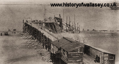 |
New Brighton Pier pictured c1860. The original wooden ferry terminal erected in 1839. |
(c) The Development of New Brighton as a Sea-Side Resort. The beginnings of New Brighton have already been indicated in reference to the building of the Ferry and the proposed laying-out of this shore. Gradually they became the haunt of a very troublesome class of people and the place for a short time had a very disreputable character. It was called 'The Nest' but by some 'The Devils Nest'.
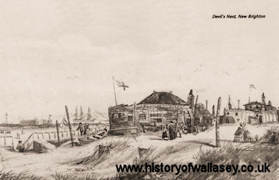 |
Devil's Nest |
(d) The Industrial Development of Southern Wallasey bordering the Pool. Following upon the abortive scheme of Tobin and William Laird (1828) for the construction of docks on Wallasey Pool and a canal joining these with Hilbre on the Dee, several industries were established on both sides of the Pool. In 1824, Laird had set up a boiler manufactory, situated at the foot of Livingstone Street in Birkenhead, to which a ship-building yard was soon added. After 1828, the firm of William Laird and Son turned their attention principally to ship-building and the use of iron instead of wood, became the pioneers in iron ship-building and constructed prior to 1840 some 32 iron vessels of all kinds.
Meanwhile, the increased prosperity of Birkenhead and the readiness of Liverpool corporation to dispose of their land holdings adjoining the Pool led to the revival of the Dock Scheme, In 1843, Mr Laird bought 48,000 sq yards at Wallasey Pool which paved the way for the purchase in all of some 200,000 sq yards by him and others from the Corporation of Liverpool. Acts of Parliament were passed in 1844 and 1845 and work was begun by which the Pool was to be turned into a vast systems of Docks, the provision of which would have given a great impetus to the growth of Wallasey and Birkenhead as well as to the whole of Merseyside. The study of the Dock construction is too long to be dealt with fully but it should be noted that in 1846, reaction set in and and although 1847 saw in April the opening of the Morpeth and Egerton Docks, it also saw the tremendous decline in Birkenhead's population from about 40,000 in January to 20,000 in December. The reason for this partial failure of the Dock Scheme are to be found in :-
(1) the unsatisfactory finances of the Birkenhead Commissioners;
(2) the work itself although well planned was badly carried out;
(3) Liverpool Corporation not only gave no support to the scheme but did everything possible to impede its progress.
The Commissioners attempted unsuccessfully to carry on the Dock scheme but in 1855, they passed under the control of the Corporation of Liverpool and then, in 1857, under that, of the Mersey Docks and Harbour Board.
In the meantime, favoured by the water facilities a number of industries had been established on the Wallasey side of the Pool including the following which appeared on tithe maps of c1841 :-
(a) Copper Works of Messrs John Bibby, Sons and Company near Creek Side, off Dock Road;
(b) Smalt Works of Dawdsley and Smith
(c) Seacombe Foundry of Messrs Pollard and Co., to the north-west of the Smalt Works
(d) Starch and Vitriol Works of Messrs Clough and Galan, just west of the Copper Works.
A little later than 1846 other industries came into existence which included :-
(e) Seacombe Pottery, which stood on the land which was partly occupied by Messrs. Currie and Rowland's works. This was built in 1851, by Mr. Goodwin of Staffordshire and at the time was supposed to be the best built and equipped pottery in England. It produced earthenware and stoneware, chiefly of a blue colour, as well as colour ware and colour-printed ware. Later, Parian ware was made in large quantities;
 |
Seacombe Pottery, 1889 |
(f) Sugar Refinery, which stood close to the pottery;
(g) Cement Works of Mr. George F. Chantrell of Leeds, established about 1855 a little north of the Copper Works;
(h) Phospho Peruvian Guano Works was situated in Havelock Street (later renamed Alfred Road) which commenced about 1830. In addition there were the Linke-kilns, shown on Eye's Survey of 1839, standing at the end of Limekiln Lane, near the edge of the Pool, but not appearing on the 1841 map.
Distribution of Land-Holders and Settlements in 1846
The combined influence of all these factors is clearly seen in a study of the settlements shown on the 1841-46 Map of Wallasey (Wallasey Village, Poulton-cum-Seacombe, Liscard/Egremont/New Brighton). This reveals that several new hamlets had come into existence since 1811, all of which were in the eastern part of the Parish, the part bordering the river and thus they were in close proximity to the three ferries with their facilities for reaching Liverpool. Here land speculation for building purpose had already begun and plots of land had been purchased from the old land-holders and their descendants. Apart from these purchases of land near the ferries and in New Brighton the land-holdings were much the same as in the earlier part of the century.
In Liscard Township the Manor had passed to John Dencil Maddock, the grandson of Thomas Maddock, Rector of Liverpool 1772-1782, who had married his first cousin Mary Anne Penkett, daughter of the late Lord of the Manor, John Penkett. His holdings formed a fairly compact block of land lying to the north, south and west of Liscard Manor House (bottom of Manor Lane). To the north-west were the lands purchased by John Astley Marsden, a brush manufacturer of Liverpool. These encircled the so-called Liscard Castle, which stood a little back from the northern end of Marsden Lane (now Seaview Road). It was a large and stately house but its battlements and stone lion embellishments resulted in it being called ironically 'Brush Castle' and later 'Liscard Castle'. Later in the century the house was divided into three part, the Turrets, the Towers and the Castle. Following upon their demolition roads were built on the site and named accordingly. In the south-west of the Township the lands of Sir John Tobin had passed by marriage and purchased to Harold Littledale, Esquire. The latter was a Cumberland gentleman, head of a great mercantile house in Liverpool (he was Mayor of Liverpool in 1827), and had married Margaret, daughter of Sir John Tobin, joint holder of the Manor of Wallasey with Robert Vyner, Esq. His lands in Liscard occupied a large part of the Old Moor, lying on either side of Liscard Road. About the centre was 'Moor Hey House', afterwards called Liscard Hall. This fine house had been built by Sr John Tobin about 1835. Just outside the Township boundary, bordering Mill Lane, was Littledale's Model Farm which until about 1870 was one of the few big sources of employment in Wallasey. This farm was an expensive hobby of Littledale and contained some 40 acres, including much of the best arable and pasture land in the whole Parish.
The steward's house and the milk and cheese house was where the dairy maids lived, still stand in Rullerton Road. Some of the cottages (with diamond pane windows) occupied by the farm hands once stood opposite the old maternity home in Mill Lane. The shippons and stables stood further inside, abreast of the cottages. For some reason the shippons never numbered more than 99 in three shippons. The piggeries near the end of Marlowe Road, and the great corn and hay stacks, with the farm buildings, stood on the north side of the shippons. The sheep farm was on the Wallasey golf-links land, the shepperd's house being at the junction of Green Lane with the path leading from Leasowe Road over the sandhills to the shore. The cows were all stall-fed, and many people believed the milk to be unwholesome on that account, but as Littledale's milk (and butter and cheese) was consumed all over Wallasey without any ill-effects being found, the story was probably untrue. Farmers came from all parts of the world to view the farm.
All the drainage from the shippons and stables drained into a large bank, which led by underground pipes to various fields, and the liquid was pumped over them after the crop had been cut, and several crops were thus collected each summer. The fields at the corner of Martin's Lane and where the ambulance station is now, were noted for their wonderful grass and corn crops.
Many of the farm hands came annually from Ireland and North Wales to work in the summer. Some of them settled in Wallasey and their descendants are still be found.
In the Township of Poulton-cum-Seacombe the land-holdings were mainly in the hands of Admiral Richard Smith and the Rev. James Mainwaring, joint proprietors of the Manor, with isolated areas owned by Robert Vyner, Esquire., including most of Poulton Common. Bordering the Pool were the sections of land purchased by the founders of the various industrial activities already mentioned, together with the holding of the Corporation of Liverpool.
In the Township of Wallasey the lands were still largely owned by Robert Vyner, Esquire, and Harold Littledale, joint-holders of the Manor, with fair-sized holdings controlled by John Shaw Leigh, Esquire, John Astley Marsden, and John Davies. There were also many smaller patches including those owned by members of the Deane family.
At this time, the middle of the nineteenth century, there were ten small settlements in contrast to the five at the beginning of the century. These were the original five: Wallasey Village, Poulton Village, Liscard Village, Seacombe Village and the small Magazines settlement together with the new ones of New Brighton, Upper or Little Brighton, North Egremont, Egremont, and Somerville.
New Brighton - The origin of this settlement has already been discussed in reference to Atherton and Rowson's scheme for the development of a sea-side resort. Building had followed and by now a number of houses and shops were in existence. These were mainly in the south side of Victoria Road and beginning from the ferry included the Ferry Hotel, a few shops at the bottom of Victoria Road, and the New Brighton Hotel, the row of houses (later shops) then St. George's Terrace (which extended from Grosvenor Road to Rowson Street). Beyond Rowson Street were a few houses reaching St. James' Church which was already in existence, and after a break came the large houses in Montpelier Crescent which were plastered with stucco and painted usually a buff colour, a style of house that of the nineteenth century. On the shore frontage moving round from the Ferry were the 'Nest' and a number of wooden erections used as shops for supplying hot water for tea to the summer visitors, then came the fine large houses on the sea-ward side of Wellington Road between Atherton Street and the Red Noses. Other small brick-built houses existed in a terrace-formation in Egerton Street.
Upper Brighton consisted of a few large houses along the eastern side of Upper Rowson Street together with a number of small, terrace-formation, brick houses that once stood immediately to the west of the Quarry Recreation Ground. The housing density map of Wallasey, 1935, showed this area was the second highest density in the whole of Wallasey, namely 64 houses per acre.
The Magazines had remained practically unchanged except for a few additions in the later half of the nineteenth century. The outstanding additions included a further terrace formation of small houses in Beech Grove (at the bottom of Holland Road and Liscard Vale (now the house and cafe in Vale Park). Nearby, at the bottom of Magazine Lane stood Liscard Hotel which in 1857 was known as New Brighton Hotel, and still later as 'The Stanley Arms'. Finally, until largely destroyed by fire in 1854, it existed as 'New Brighton College' under the control of Dr. Poggi, a friend of Garibaldi whose two sons Riclotti and Menotti were educated there.
North Egremont lay further to the south between the newly constructed Manor Road (prior to 1841) and Trafalgar Road. It included a number of large houses on the new Seabank Road (joining Manor Road to the new roads King Street and Brighton Street that led through North Egremont and Egremont to Seacombe Ferry) and along Trafalgar Road. In addition, there were a number of smaller houses between what is now Stringhey Road and Poole Road.
Egremont as previously mentioned, had grown up behind John Askew's Ferry and comprised a number of large houses laid out in connection with several newly constructed roads. Church Street was the chief road leading from the ferry approach westwards to St. John's Church which had been erected by Sir John Tobin. Other roads were Union Street and Burnaby Street, the latter forming a narrow street between the backs of the houses in Church Street.
Seacombe had developed considerably but most of the property was made up of small houses in the Mersey Street area (which were demolished in the 1930s as an unhealthy area and re-built with then Corporation Houses at a density of 18 houses per acre) and Demesne Street and Brighton Street. Better class houses existed along Victoria Road (now Borough Road). Church Road had been constructed leading from the Ferry to St. Paul's Church, the foundation stone of which was laid 6th June, 1846. The church was built during the succeeding year in the Early Middle Pointed Style of the 13th Century with a spire 120 feet high completed in 1849. To the south-west of the Church and extending on both sides of Wheatland Lane were the small houses built probably to accommodate the employees of the Phospho Peruvian Guenon Works in Havelock Street (now Alfred Road), and the other industrial works bordering the Pool.
Somerville, lying about mid-way between Poulton and Seacombe, consisted of about a dozen very fine, large houses fronting on the Poulton Road with a few smaller houses at the back facing the present Halstead Road. Almost mid-way between Somerville and Poulton, Gorsey Lane had been constructed leading south-west from Poulton Road to the Docks which were in construction at this time (1846).
Liscard Village, situated at some distance from any of the ferries had remained practically unchanged until the construction of two long terraces of small brick-built houses along the present St. Alban's Road and Terraces. These properties were possibly built for the people employed on Littledale's Model Farm (the houses remained until the 1960's until being demolished to make way for Dominic House and town centre car park). Also properties were built along Egerton Grove as well as half a dozen larger houses had been built along the western side of Marsden Lane (now Seaview Road) near where Fairview Avenue is today.
Poulton and Wallasey Village, likewise, showed little signs of development in regard to housing which has explained by their distance from the ferries.
The growth of population and the associated settlements resulted in the appointment in 1845 of Commissioners to undertake the paving, lighting, watching, cleansing and improvement of the Parish. Unfortunately, the Commissioners appointed almost wholly neglected their duties and sanitary conditions became so bad that in 1851 a considerable number of the inhabitants of Seacombe led by their Incumbent Rev. Edward Roberts, petitioned the General Board of Health to appoint an inspector to visit the locality and to report thereon. Subsequently, in the same year, an Enquiry was held at Parry's Hotel, Seacombe, by Mr. Robert Rawlinson, Superintendent Inspector under the Public Health Act. His report gives an interesting picture of the very unsatisfactory state of affairs in the Township of Poulton-cum-Seacombe. it revealed that there were no public lights in the parish, and only a small private gasworks which supplied Egremont Ferry, no public supply of water, and that the roads were very dirty, specially in winter. The housing conditions in the Mersey Street area, adjoining Seacombe Ferry were described as abominable and the mortality rate in Poulton-cum-Seacombe "was excessive and that with all the natural advantages of the locality, it was greater than even in the worst districts of Liverpool. The unsanitary conditions had partly arisen in the way described by the Seacombe petitioners as follows :-
"We have to observe that all the drains and sewers from the houses and water-closets of the village of Seacombe deposit their filthy contents upon the shore, the stench from which is not only highly offensive to the senses but extremely prejudicial to health.
That before a certain embankment was raised by the Trustees of the Birkenhead Docks, the tidal waters of the River Mersey washed the before-mentioned shore daily, and consequently removed all impurities; that the said tide is now excluded, and that a cesspool is formed within the said embankment, which engenders malaria, and will in the coming hot season be a fruitful source of fever and diseases to a neighbourhood already notorious for its unhealthiness".
The Inspector also expressed the opinion that conditions in the Parish of Wallasey generally were similar to those in Poulton-cum-Seacombe. Inevitably, this report resulted in the displacement of the existing Commissioners and in 1853 a Local Board of Health was created under the Public Health Acts of 1848 and 1853. The progress of Wallasey under the Local Board of Health and its successors in public administration forms the subject matter as we continue the story of Wallasey into the second half of the nineteenth century.