Wallasey Districts
Moreton
&
Saughall Massie
Few places on the Wirral have altered more then Moreton. Since the district was incorporated in the Borough of Wallasey in 1928, the green meadows which surrounded and isolated the village have been carved up into dozens of roads serving a vast housing scheme which was required due to a housing shortage after Post World War One. Saughall Massie was later incorporated in 1933 and it is here we will begin with.
The name of Saughall Massie is English and is from 'Seallh' meaning Willow and 'hale' standing for slope. So the fist part, Saughall means 'The Slope of Willows'. Hamo de Mascy, grandson of one of William I's nobles, held the land. On account of there being more than one Saughall in Cheshire, the Massy family decided to add their name to the village so as to identify it.
Hamo de Mascy is well remembered on the Wirral as founder of Birkenhead Priory in about 1150. Saughall was part of the barony of Massys of Durham Massey.
The Massey family held the land for many years, one of them allowed the Abbot to remove sixty wagon loads of turf from the Moss. The land passed through various hands, including John Lestrange and Sir John Stanley and so to the Earl of Derby.
Looking at Saughall Massie today you would wonder what has changed over the years apart from the shrubs and trees being more established, because the village has remained a quiet rural area.
Saughall Massie was once a township within the Bidston Parish, and became a civil parish in 1866. In 1933 the three Lanes End area was devolved to Grange in West Kirby and the remainder was incorporated within the borough of Wallasey. The population was 98 in 1801, 176 in 1851 and 186 in 1901. Some of the surnames associated with the village are Wilkinson, Bennett, Broster, Brassey, Smith, Godwin, Harrision and Morgan to name a few.
The village consists of a number of historic buildings dating from the seventeenth century. In order to help preserve its historical and agricultural characteristics, Saughall Massie was designated a conservation area in January 1974.
Much of the history of Saughall Massie is contained in the history of one of its dwelling houses, which was originally built in about 1323. In 1323 Lucy, the wife of Robert, son of Henry de Saughall (Henry de Salgal) obtained by fine from Robert the Earl, a tenement in Salghal Massey. This building has long since been demolished. It was a cottage, possibly half timbered and stood on the corner of Saughall Massie Road and Saughall Road. It was re-built in 1690 and again in 1953. Robert Blackburn Hill purchased the property in the 1950's with the intention of making it his home, but found the building so much in need of repair that he decided to have it demolished and a new house built. He used several pieces of the old sandstone from the old white-washed two storey cottage in the new construction.
 |
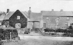 |
Ivy Cottage is a fine state of preservation and is thatched. It was the last thatched cottage in the Old County Borough of Wallasey. The house plate carries the date of 1690 and the initials G.A.E. They are of Arthur and Ellen, his wife, Godwyn. The Broster family have lived their for generations.
The farm close by is Prospect Farm and in Saughall Road we have a cottage which was built in 1714 with house plate :
| P. | = |
Peacock |
| S.X | = |
Saughall? |
| I.J | = |
John and Jane (nee Webster) |
| 1714 |
The Peacocks were a popular family in the village. Near the cross roads in the village there is a house with a plate inscribed :
| P. |
| D.M |
| 1714 |
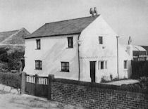 |
'The Elm's' was built in 1670 and said to be the oldest cottage in the village. The house plate carries the initials S.G.A. The 'S' stands for Smith or Sefton and the others for George and Anne. 'Diamond Farm' was built in 1728. In 1911 John Wilkinson (born about 1862 in Saughall Massie) and his wife Elizabeth and their five children worked the farm. The date plaque outside has the initial :
| H. |
| T & E |
| 1728 |
The initials standing for Thomas and Elizabeth Harrison who were earlier occupiers and raised a very large family at the farm. Diamond farm is still in the village.
The Saughall Mill existed as early as about 1580. It was one of the four windmills in Wallasey. In the past it was used by the smugglers as a place to store contraband. Secret meetings were held in the old building and men would gather around a small light to plot their evil deeds.
The Vyners owned the mill at one period and Ester Martin lived in it at one time, paying a rent of £6 a year. The last miller to use the building was a man by the name of Richard Hale. This old ruin was finally demolished in about 1871.
An area in the northern part of Saughall Massie was known as the 'Old Carrs'. Carr is a middle English word meaning marsh and the name is perpetuated in the present Carr Lane; similarly the area once known as Sandbrook is perpetuated in the present Sandbrook Lane. Some of the field names in use in 1665 were 'The Banakers', 'Neere Wimbrick', 'Gosty Pellitan Hey', 'Barcroft Hey', 'Werrettbay' and 'Cherrie Tree Bay'.
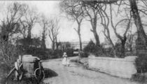 |
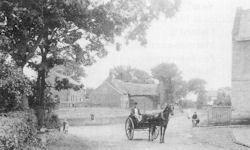
Saughall Massie Bridge was the first to be built by the civil engineering contractor Thomas Brassey in 1829. Brassey was paid £200. He was born in Buerton, six miles south of Chester and, by the time of his death in 1870, he was to go on and build one mile in every 20 miles of railway in the world. The bridge was awarded Grade II listed status by English Heritage in 2007. A plaque commemorating this event was unveiled and an information board erected nearby.
A visitor to Moreton in 1847 wrote :-
It is situated in a dreary flat, close to the shores of the sea, with roads excessively bad, and a bridge as dangerous to travelers as it is disgraceful to the country. it is, in every point of view, an extremely poor village, and a greater part of the township is below the level of the sea at high water.
The name Moreton is English and means 'the village on the lake'. The land was very marshy many years ago, as seen by the field names such as South and North Home, Home Hey, Holme Intake. The word Holme means an island in a river. Then fields with the name carr - an old English name depicting a marsh. There was the Old Carr, New Carr, Saughall Carr and Moreton Carr. We also find field names of Dale hooks, Big Hey Hooks, Little Ley Hook. 'Hook' means a field which juts out into a lake. Lastly, the Little Pringle and The Pringle. The word 'Pringle' means an enclosure surrounded by deep ditches.
Like Saughall Massie, Moreton was held by Hamo de Mascy and followed roughly the same history as regards landowners.
 |
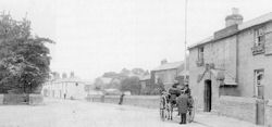
There was only one main route through the village and this was known as Pasture Road but was formerly Station Road. The other main avenue for traffic, the Turnpike Road, was not built until 1841. This crossed the township in a westerly direction running from Bidston to Saughall Massie. It was known by a variety of names : Fender Lane (after one of the two streams which drain the marsh), Birkenhead Road, Hoylake Road, Main Road and Village Road. With the incorporation of the parish of Moreton in the Wallasey Borough it was decided to alter any Moreton street name which might be confused with similar street names in Wallasey. The Council also decided that where more than one name was used for a Moreton street they would resolve all difficulties by decided once and for all by which name it would be known. In the case of the Turnpike Road the Council decided that it would henceforth be known and described as Fender Lane from the Bidston boundary to Reeds Lane, and Hoylake Road from Reeds Lane to the Saughall Massie boundary.
Barnston Lane (running parallel to Pasture Road) was originally called Chapel Lane, and the small chapel after which the lane was called, stood there many years.
A lane opening off Pasture Road was originally known as either Townmeadow Lane or Mary Anne's Lane after the owner of a cottage in the lane. In order to prevent confusion the Council decided that the first 210 yards from Pasture Road should be called Marylands Lane and the remainder Townmeadow Lane.
Similarly the road which was known as either Lingham Lane or Lighthouse Lane is now known as Lingham Lane. The name Cecil Avenue, which might have been confused with Cecil Road, Wallasey, was changed to Griffin Avenue after Canon Griffin, who was formerly at the Church of the Sacred Heart, Moreton and a member of the Borough Council.
Glasier Road, Hardie Avenue and Snowden Road are all named after prominent politicians; James Keir Hardie was a pioneer of the socialist movement and Philip Snowden was Chancellor of the Exchequer in the first Labour Government in 1924.
A survey of the 'Manor of Bidston', made by Lord Kingston in 1665, contains lists of the tenants of the four townships and maps showing the disposition of houses and roads; each field bears a name and of that its tenant. The survey map of Moreton showed the main street passing through the village on the site of the present Pasture Road and a back lane running parallel to it on the site that is now Barnston Lane. On the east side of the main street were the houses of Henry Robinson, William Bennett, Richard Lenaker and James Bird; on the west side, two of the Urmson family, Thomas Watt, William Hancock (a tenant of Sir Philip Egerton), and John Rathbone lived. There were many cross paths between the houses.
The old chapel stood on the western side of the village green with a marypole to the north of it and nearby were the tithe barn and the village 'pound'. The chapel was a small rectangular building with a doorway on the south side, a belfry over the western gable and a cross over the eastern one.
The name of the Reverend William Bymson appears in the Bishop's visitation book for the parish of Bidston in 1554 and he probably served the chapel at Moreton. The Reverend William Edmundson was at the chapel in 1571.
In September, 1592. George Pemberton of Moreton was brought before the Consistory Court at Chester 'for sitting upon the cross at service time and would not go in at the Churchwardens' request'.
The chapel appears to have been dependent on a levy of the householders, and in 1598 Robert Wade, William Hancock and William Pemberton were before the Consistory Court for refusing to pay their dues. The church record states (they) 'do utterlie refuse to contribute to the said Chappell. The saide parties appeared and the Judge hathe injoined them to paie according as heretofore they have done to the said Chappell.'
Bishop Gastrell in his Notitia Cestriensis gives the following note :
Moreton - A chapel in Bidston Parish in Sir P. Leycester's time. Demolished 30 years ago. No settled endowment, as certified by the Minister of Bidston, 1719.
In the Bishop's visitation book for the year 1742 it is stated that 'Moreton Chapel in Bidston Parish is ruinous'.
On the extremity of the village bordering on to Saughall Massie was the meadow for the town bull. Commons occupied the eastern side of the township, and in the north and north-west were other common and pasture lands.
The list of Lord Kingston's Moreton tenants in 1665 is as follows :-
| John Pemberton | 2 acres |
| Will. Bennett | 37 acres |
| Rich. Lenaker | 23 acres |
| James Bird | 21 acres |
| Mary Urmston | 1½ acres |
| Jon. Rathbone | 36 acres |
| Thomas Wats | 28 acres |
| John Urmston | 5 acres |
| Wm. Hancock | 8 acres |
John Anderton, William Dod, John Gowen, Ellen Graviner, Rich. Pemberton, Thomas Urmston and John Upshon, all had holdings of less than one acre. A piece of land at Overgreen, outside the border, was assigned to the constable.
Situated in Barnston Lane, Old Hall Farm is one of the oldest houses in Moreton, being built in 1719. Inside it boasts a Tudor style grate and Jacobean ceiling, Further additions have been added at a later date. The house plate is triangular shaped with the initials W.D.M., which stand for Daniel and Mary Wilson. It carries the date of 1719.
The father of Daniel Wilson, Robert, lived in Bidston Hall and was a Presbyterian who organised services in his home. At the time of the reign of Charles II a troop of horse searched Bidston Hall and other places for arms and recovered 122 guns, pistols etc.
Daniel married Mary Ensdale of Meols on 15th September, 1688 and less than a year later they baptised their first child, Robert, on 18th August, 1689. On Daniel's death in 1737 the property was left to his grandson, Thomas.
Thomas Wilson had no children so the property was passed to his sister Catharine Gardener in 1776 thus severing the connection with the Wilson family and the house on Barnston Lane.
For a full history of the churches in Moreton please click the link Moreton & Leasowe Churches.
 |
 |
 |
 |
Other Principle Moreton Buildings
 |
The Farmers Arms is situated on the corner of Barnston Lane and Netherton Road (then known as Smithy Lane). The pub dates back to at least 1860 when William Naylor was the landlord. The pub was demolished in 1930 and a new one erected on the site. The car parking area in front of the present building is the site of the old inn.
 |
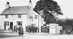
The old Plough Inn & Druids Arms stands in Hoylake Road (then known as Birkenhead Road). It has been said that there has been an inn on this site since the 1600's. The original building was built from local sandstone but in c1931 the old Inn was demolished and another built on the site. In 2011 the Plough Inn was demolished and replaced with Tesco's.
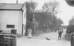 |
Mary Anne's Cottage once stood at the junction of Mary Anne's Lane and Pasture Road (then known as Station Road) opposite Ivy Farm. The cottage was three buildings in one and was demolished in 1931 when Pasture Road was widened. Mary Annes Lane was renamed Old Maryland Lane.
 |
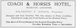
The Coach & Horses is situated on Pasture Road and dates back to the 1800's. As with all the pubs in Moreton the original was demolished. The present one being rebuilt in 1928.
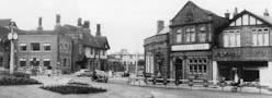
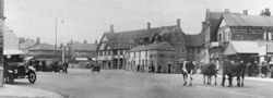
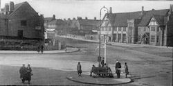
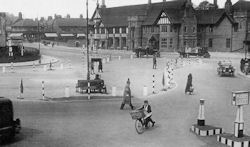
Moreton Cross :- The three pictures below are taken between 1933 - 1937 and show the development of Moreton Cross : More information is shown when you click on each picture.
 |
 |
 |
The Shanty Town - In the 1920s Moreton had a large number of makeshift homes, made of all manner of materials, and old tram cars and huts. The roadways were also bad, especially in wet weather. Moreton became known as 'Shanty Town' and when Wallasey took over, they took the necessary steps to improve the situation. Flooding due to heavy rains, was always a problem when folk had to take to rowing boats to enable them to leave their homes.
By the outbreak of the Second World War over 1,470 such properties were removed on health grounds and in the 1980s there is not one left.
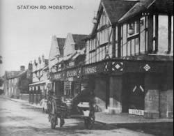 |
Moreton Picture House - The Picture House was built on the site of old cottages and the village pump. Situated at 16 Station Road (later Pasture Road) the cinema opened on Saturday 30th April 1921 and the first manager was Mr W.W. Wright. The first film to be shown was 'Wit Wins' starring Florence Billings and Hugh Thompson and directed by Burton L. King. With the Moreton area being unbuilt, the people of Wallasey would generally only pass through on their way to rural parts beyond. Therefore, the appeal of the cinema was aimed at, not just the local populace, but also the surrounding district. In fact free storage was offered for their bicycles.
Cheshire Picture Halls, who owned the cinema, had become part of the S.M. Super Cinemas circuit by 1937 and the Moreton Picture House continued to operate under their management until the company in turn was taken over by the Essoldo chain in 1954.
The Moreton Picture House closed on 28th March 1964 with a showing of 'Flight of the White Stallion' starring Robert Taylor and Lilli Palmer. Currently the building is now being used as a bingo hall.
References
Almost An Island - Noel E. Smith
The Rise & Progress of Wallasey - Woods E Cuthbert and Brown P Culverwell
The Silver Screens of Wallasey - P.A Carson & C.R Garner
Yesterday's Wallasey & New Brighton 1860 - 1960 - Ian Boumphrey