You will find an extensive A - Z list of properties that are either still here today or have long gone. The list includes names of private houses and cottages as well as names of terraces. The list is far from complete and new information will be included periodically. Each property listed may include a brief history and, where available, images and maps.
| Achaia Terrace | |
| Acorn Villas | |
| Adelaide Terrace | |
| Albert Terrace | |
| Albert Terrace | Range of ten properties on Green Lane (renamed as Greenwood Lane) between Brook Street and Walmsley Street. [MAP 1898] |
| Alexandra Terrace | |
| Alma Terrace | Three private residences situated on the corner of Queen’s Road on Brighton Street. Demolished to make way for the Town Hall. [MAP 1875] |
| Alpine Cottage | House on Burns Avenue [MAP 1954] |
| Anchorage | See 'Sea View House'. |
| Arvon Terrace | |
| Auburn Terrace | Row of six properties on Hope Street, New Brighton [MAP 1909] |
| Austin Terrace | |
| Bank House | Situated close to the Seacombe Hotel, on the corner of Borough Road (then called Victoria Road) and Mersey Street. Bank House was originally known as ‘Green Bank’ in the 1870s and the occupier was a wine and spirit merchant, John Andrews. A multi-storey block of flats, Mersey Court, now occupy the site. [IMAGE] |
| Bankfield House | Located close to the Leasowe Lighthouse and was built in 1790. The Georgian house is built of common brick |
| Baroda Villas | Three private properties standing at the top of St. Lucia Road on Seabank Road. |
| Beach Bank | Four private residences located stretching between Manor Road and Manor Lane where No. 121 Manor Road is today. [MAP 1875] |
| Beech Grove | Range of 22 properties on Beach (once called Beech) Grove, off Holland Road. [MAP 1898] [IMAGE] |
| Beach Villa | Two properties facing on to Manor Road. [MAP 1875] |
| Beaufort Terrace | A range of properties on the east side of Brighton Street that stretched from Brougham Road to North Meade House. They were a mix of private dwellings, shops as well as a doctor’s surgery. North Meade House would later be demolished to make way for the Town Hall and the houses demolished in the 1960s. [MAP 1875] [IMAGE] |
| Belle Villa | House situated on Belgrave Street [MAP 1875] |
| Belmont Terrace | Range of properties on Tollemache Street [MAP 1909] |
| Belmont Villa | Situated off Rake Lane at the back of the shops where Sandrock Close is today. Built about 1840 and was later made into two dwellings. In the cellar there was a furnace of sorts that heated the water for the outdoor swimming pool and pipes ran to heat the greenhouse. Was left in a state of ruins for awhile and demolished in the 1990s. [MAP 1875] |
| Belvidere Terrace | Originally a row of 9 cottages in Liscard which later was replaced by range of shops from No. 276 to No. 296 Liscard Road. Various local shops such as Campbell’s Sport Outfitters, Boots, Woolworths and Coombes occupied the site. [MAP 1898] |
| Bickley Parade | Five properties that once stood at the bottom of Victoria Road opposite the Royal Ferry Hotel. Ducker’s Cafe was once situated at No. 5. [MAP 1909] |
| Bird’s House | Located on the west side of Limekiln Lane which was built in 1697, which makes it Wallasey’s oldest inhabited house. The house was the home of William and Mary Bird. William was a Yeoman and a Churchwarden of St. Hilary’s. [IMAGE] |
| Bootle View | |
| Braddofields | See Mansions of Wallasey: 'Around The Grove'
|
| Bramble Terrace | |
| Breck Hey | See Mansions of Wallasey: 'Around The Height'
|
| Breck Place | |
| Brick Cottage | The property stood on the high crowd of Breck Road [MAP 1898] |
| Bright Terrace | Set of six properties located on the corner of Field Road and Eleanor Street. [MAP 1909] |
| Brighton Terrace (1) | Row of four properties on Brighton Street between Leopold Street and Borough Road. [MAP 1909] |
| Brighton Terrace (2) | Range of nine properties on Victoria Road between Mason Street and Grosvenor Road. [MAP 1909] |
| Brougham Terrace | Four properties between New Street and Wheatland Lane, facing Birkenhead Road. [MAP 1909] |
| Brow Cottage | House opposite the Magazine Hotel on Magazine Brow which once faced the river. Home of the Arthur family. The house was later demolished in 1974 due to a gas explosion. [MAP 1954] |
| Burwen Terrace | Row of properties that stood on Gladstone Road. [MAP 1909] |
| Busby Cottages | Five private residences built in 1891 off Field Road, New Brighton, by Robert Busby, owner of Wallasey United Tramways, for staff employed at the Depot. [MAP 1898] |
| Buxton House | See Mansions of Wallasey: 'Around The Grove' |
| Cambrian Buildings | Two buildings situated between Borough Road and Little Street on Brighton Street. [MAP 1909] |
| Cambrian Terrace | |
| Carlile's Cottage | |
| Catherine Terrace | |
| Chapel Terrace | Four properties on Egerton Street, New Brighton. [MAP 1909] |
| Church View | |
| Clairville | A cottage located near the corner of Moseley Avenue on (No.28) Wallasey Road, Liscard. The property appears on Tithe maps of 1841. In 1921 William J. Caddock, a gentleman, was noted as the occupant. Later the property was demolished to make way for Central Market Buildings and by 1967 made way for Safeway Supermarket. Today it is a Wetherspoons pub called 'The Clairville'. [MAP 1898] |
| Clare Mount | See Mansions of Wallasey: 'Around The Grove' |
| Clare Villas | Three properties on Tollemach Street [MAP 1909] |
| Claremont Terrace | Row of five properties in Poole Road, Egremont [MAP 1898] |
| Claremont Villa | See Mansions of Wallasey: 'Wellington Road Villas' |
| Cliff Villa | See Mansions of Wallasey: 'Wellington Road Villas' |
| Clifford Cottages | Two properties on the corner of Rice Lane and Gresford Place [Map 1898] |
| Clifton Cottage | Situated opposite Burns Avenue on Seaview Road. By the late 1890's the property was divided into two. The property was used for many years by Woods Motors Showroom:Nos 86-90 [MAP 1898] |
| Clifton Hall | |
| Clifton Terrace | Seven properties on Withens Lane, near the corner of Urmson Road. Two of the properties on the corner of Urmson Road were demolished. [MAP 1898] |
| Clifton Villa | See Mansions of Wallasey: 'Wellington Road Villas'
|
| Clwyd Terrace | |
| Comely Bank | |
| Concertina Cottages | See 'Concertina Cottages' |
| Constantine Terrace | Row of six properties once located off Field Road [MAP 1909] |
| Creek House | The house once stood off Dock Road, at the top of Creek Side. [MAP 1909] |
| Cyprus Terrace | Five properties situated off Sandfield Road. [MAP 1954] |
| Dale House | Two properties on Wheatland Lane, on the corner of Oakdale. [MAP 1909] |
| Dalmorton House | See Mansions of Wallasey: 'Mansions of Rowson Street' |
| Darley Dene | See Mansions of Wallasey: 'The Breck' |
| Dean's Cottages | Range of four properties in Wallasey Village, opposite Green Lane. [MAP 1954] |
| Dean's Terrace | Four properties in Liscard Village which was built in 1782 and was originally three storeys high. Only the end property exists – The Royal Oak pub. [MAP 1952] |
| Denbigh Terrace | |
| Denmark Terrace | |
| Dinorben Terrace | Set of six properties between Catherine Street and Eleanor Street on Field Road. [MAP 1909] |
| Dodd's Cottage | |
| Earlston House | See Mansions of Wallasey: 'Around The Height'
|
| East View | |
| Edlington Villa | House situated in Belgrave Street [MAP 1875] |
| Egerton Cottage | Three small thatched cottages in Egerton Grove, Liscard Village, which were demolished in 1913. [IMAGE] |
| Elleray Park | See Mansions of Wallasey: 'Around The Height' |
| Ellerslie | See Mansions of Wallasey: 'Wellington Road Villas' |
| Ellesmere Terrace | Row of properties in Poole Road, Egremont [MAP 1898] |
| Elm Cottage | Stood on Poulton Road, opposite the end of Love Lane. Alfred Hopps bother, Edmund, resided here. Edmund worked in the family’s oil business in Liverpool and was also Secretary of the Reading Room in Limekiln Lane. [MAP 1909] |
| Eves Cottage | The property is situated at 23 Magazine Brow and was built in 1670. The basic structure is stone built and whitewashed to protect it from the weather. The property was originally built for fishermen and was really two small cottages when first built [IMAGE] |
| Ewart House | See Mansions of Wallasey: 'Wellington Road Villas' |
| Ewart Villas | See Mansions of Wallasey: 'Wellington Road Villas' |
| Eyrie, The | The property was originally called 'Eagle Lodge' and stood on the Breck Ridge. Mr. Charles Crewe Chambres, brother of Major Chambres who resided at Mosslands, lived at Eyrie. William Carson, once manager of Wallasey Ferries, also lived here. [MAP 1898] |
| Fairfield House | A private resident that was located on the corner of Earlston Road and Rake Lane. Demolished and smaller houses built on the site. [MAP 1898] |
| Fairholme | Private house at No.10 Prospect Vale, Wallasey Village [MAP 1954] |
| Fairview | |
| Fern Hill | See Mansions of Wallasey: 'Mansions of Rowson Street'
|
| Fern Villas | |
| Field Cottages | A range of private dwellings once situated off Liscard Crescent. [MAP 1898] |
| Finnegan's Cottage | Small whitewashed cottage which was also known as 'Bates Garden's. The cottage was located off Rice Lane. It was said to been built for Harold Littledale's under-gamekeeper. The cottage, which was demolished in 1925 to make way for housing, was a double-lean-to-building with a tarred and felted roof. [MAP 1898] [IMAGE] |
| Fireman's Cottages | See 'Stone Cottages' |
| Florence Cottages | Five cottages once located off Field Road. [MAP 1909] |
| Fort Cottage | |
| Fort Terrace | Three properties built in the 1840s located on Victoria Road, New Brighton, numbered 5, 6 and 7. |
| Franchise Terrace | |
| Gap Cottage | Once located at the bottom corner of Sandon Road (then a trek way called Codling Gap). In 1864 Mr John Green resided at the cottage. Demolished by the early 1900s. [MAP 1875] |
| Garden Cottages | Four private properties situated near Wood Lane in Wallasey Village. [MAP 1898] |
| Glade Cottage | Cottage situated on Oakdale Road [MAP 1875] |
| Glade Terrace | Row of properties on Wheatland Lane which stood between the flyover and Cross Street. [MAP 1909] |
| Gladstone Terrace | Two properties on Field Road, located next to the old Mission Hall. [MAP 1909] |
| Glendale | Private house located on Manor Lane, North Egremont. [MAP 1954] |
| Gomer Gardens | Row of properties between Little Street and Chapel Street on Brighton Street. [MAP 1909] |
| Gorselands | See Mansions of Wallasey: 'Around Albion Street'
|
| Gothic House | |
| Greenbank | See Mansions of Wallasey: 'Mansions of Rowson Street'
|
| Greenfield Cottages | Eleven properties off Union Street (Guildford Street). Garages now occupy the site. [MAP 1875] |
| Greenheys | Once stood on Grove Road close to where the Nelson Hotel is today. It was once the home to Richard Lowndes who lived in the house in 1863. He was a member of the Wallasey Local Board. Another resident later on was Frederick Woolven Finn, J.P., the well-known ship-owner. He gave the piece of land known as Flyn’s Piece to the villages for the purpose of digging marl to mix with sandy soil. The property was demolished by the 1950s. [MAP 1909] |
| Grennan, The | See Mansions of Wallasey: 'St .George's' Mount'
|
| Grosvenor Cottages | Three properties on the left hand side of Borough Road between Brighton Street and Florence Road (between No. 90 and No. 92). [MAP 1909] |
| Grosvenor Square | Five properties on the left hand side of Borough Road between Brighton Street and Florence Road (between No. 92 and No.136) |
| Grosvenor Terrace (1) | Row of properties next to Seymour Street on Grosvenor Road, New Brighton. [MAP 1909] |
| Grosvenor Terrace (2) | Row of properties on Hope Street, New Brighton [MAP 1909] |
| Grove, The | |
| Grove Arcade | A row of eight shops with the Grove Hotel above the premises that is located on the corner of Grove Road in Wallasey Village (road). At the end of the row of shops was Reece's Cafe. Another business was 'Criterion Bazaar Company' who were stationers and newsagents. Fire in the 1960's badly damaged the hotel which saw the corner property demolished. [MAP 1954] [IMAGE] |
| Havelock Buildings | A row of seventeen houses in Havelock Street (now Alfred Road), located on either side of Brotherton Street. Business premises now occupy the whole site. [MAP 1909] |
| Haven Holme | Private house at No.12 Prospect Vale, Wallasey Village [MAP 1954] |
| Hawthorn Cottages | Range of cottages between Borough Road (then Victoria Road) and Abbotsford Street. Properties appear in 1855 Wallasey Local Board Health Map [MAP 1909] |
| Heath Bank | See Mansions of Wallasey: 'The Breck'
|
| Heyfield House | Stood on Withen's Lane, Liscard. By 1900s the site became the Old Manor Club. [MAP 1898] |
| Hibernia | Property standing behind the Lighthouse Inn, Wallasey Village. Demolished by 1966 when the new pub was built. [MAP 1954] |
| Hickman’s Cottages | A row of thirteen houses built in the 1830’s on Rankin Street, Poulton, and were numbered as 44 to 66. The houses were named after the builder. The first two houses were converted into a public house, The Eagle Arms. In the 1960’s the houses were demolished to make way for a housing estate – only the Eagle Arms surviving. [MAP 1909] [IMAGE] |
| Highfield House | See Mansions of Wallasey: 'Egremont & Liscard'
|
| Hillside Cottages | |
| Home Croft | See Mansions of Wallasey: 'Manor Road & Withens Lane' |
| Home Lea | Private residence located in Manor Lane, North Egremont [MAP 1954] |
| Hope House | See Mansions of Wallasey: 'Poulton-cum-Seacombe' |
| Hope Terrace (1) | |
| Hope Terrace (2) | Row of three properties in Poole Road, Egremont [MAP 1898] |
| Horton Villa | See Mansions of Wallasey: 'Wellington Road Villas' |
| Hose Side House | See Mansions of Wallasey: 'Around Grove Road' |
| Hughes Cottages | Four houses on Manor Road between Liscard Village and Grosvenor Street. Today they are numbered 28 – 32. [MAP 1898] |
| Imperial Buildings | Located on the corner of Rowson Street in Victoria Road and built in the 1870s. Three properties in the range which included the Bank. |
| Ingleside | Private house situated at No.6 Prospect Vale, Wallasey Village [MAP 1954] |
| Inveresk | See Mansions of Wallasey: 'Wellington Road Villas'
|
| Irlam House | Private house that once stood between Seaview Avenue and Longview Avenue on Seaview Road. In the early 1890's was the home of Ellis Davies, corn merchant and local miller, who sat on the Wallasey Local Board. |
| Ivy Cottage | |
| Ivy Lea | Row of properties which stood between Shakespeare Road and Milton Road. [MAP 1909] |
| Ivyleigh | Private residence located in Manor Lane. North Egremont [MAP 1954] |
| Jones Cottage | Situated at No. 1 Wallasey Village, the cottage was once the 'Ring O Bells' and then turned into a house and a shop run by Jack Jones. The cottage was demolished by 1921 when the road was widened. [IMAGE] |
| Keenan’s Cottage | The cottage was opposite the water tower in Mill Lane, and was occupied by Harry Keenan who was the caretaker and therefore the key holder of the Tower. In 1881 he lived there with his wife Ellen, her brother William Doughy and her niece Mary Ellen Kay. In later years Mary Ellen married Peter Smith and may have been the ‘Granny Smith’ when the cottage was nicknamed Granny Smith’s. The cottage was approximately where Dinmore Road is now. [IMAGE 1] [IMAGE 2] |
| Kemuel Terrace | Three properties that stood next to the entrance to the Tower Grounds, Egerton Street. [MAP 1909] |
| Kendrick's Cottages | Range of properties in Wallasey Village which included the Lighthouse Inn. All demolished when the new pub was built in 1966. [MAP 1898] |
| Kingscourt Cottage | Property on Imperial Avenue. Demolished to make way for flats [MAP 1954] |
| Kirk Cottages | Three private properties off Earlston Road that date from 1829 and originally belonged to the Molyneux family. [MAP 1875] |
| Laburnum Villas | |
| Laund, The | See Mansions of Wallasey: 'Around The Grove'
|
| Laurel Cottage | Private house at No.8 Prospect Vale, Wallasey Village [MAP 1954] |
| Laurel House | |
| Laurel Villas | 3 properties on Wheatland Lane, on the corner of Cross Street [MAP 1909] |
| Lighthouse Cottage | Property standing behind the Lighthouse Inn, Wallasey Village, which was demolished by 1966 when the new pub was built [MAP 1954] |
| Lilac Cottage | A cottage located at No. 11 Martin’s Lane. The house place is in the front of the house and carries the initial of “D” and “LE” underneath what could be either 1694 or 1624, which could make it the oldest house in Wallasey if Bird’s House in Poulton is 1627. [MAP 1898] |
| Lingfell Villas | |
| Liscard Castle | See Mansions of Wallasey: 'Around The Height'
|
| Liscard Hall | See Mansions of Wallasey: 'Egremont & Liscard' |
| Liscard House | See Mansions of Wallasey: 'Egremont & Liscard' |
| Liscard Lodge | Located back from Mount Pleasant Road and dates back to the 1830's. The residence was approached from two gates which opened onto a drive with trees on either side which ran to the house. Whilhemina Fletcher was the occupant in 1897. The house was demolished in 1910 and the site was later occupied by Wallasey Secondary Technical School which opened in 1938, offering technical education for boys and girls. The boys department was on the ground floor and the girls' department on the first floor. By 1960 the boys had moved to Mosslands Drive and the girls to Oxley Avenue in Leasowe and the building became Quarrymount School for Girls. |
| Liscard Manor House | See Mansions of Wallasey: 'Manor Road & Withens Lane' |
| Liscard Terrace | Range of ten properties located where Liscard Crescent is today. [MAP 1875] |
| Liscard Vale House | See Mansions of Wallasey: 'Vale Park Mansions'
|
| Littler’s Terrace | |
| Long Acre Cottage | |
| Longland Hey | Range of properties on Longland Road [MAP 1898] |
| Longland Terrace | Range of properties on Langland Road [MAP 1898] |
| Longland View | Range of properties on Longland Road [MAP 1898] |
| Longview House | The property was located on Seaview Road and had a very large garden. The property was demolished in the 1900’s and gave the name to the avenue. [MAP 1875] |
| Lorne Terrace | Row of six properties in Park Street [MAP 1898] |
| Ludlow | Property located on Leasowe Road, close to Reeds Lane [MAP 1954] |
| Magazine Lodge | Five bedroom property that once stood at No.9 Magazine Lane, next to the Magazine Hotel. It was a double-fronted house with a cast iron balcony. |
| Magster Cottage | |
| Manor Bank | A row of eight houses located on Manor Road, opposite the Wallasey Central Conservative Club Bowls. [MAP 1898] |
| Manor Lodge | See Mansions of Wallasey: 'Manor Road & Withens Lane'
|
| Manor Mount | |
| Manor Terrace | Two properties on Manor Road opposite Queen Street. The houses were built in the 1800s and were once used as Whitby’s Dairies and later as a photographic business. Demolished to make way for modern flats. [MAP 1898] |
| Manor View Terrace | |
| Marine Parade | |
| Marine Terrace | |
| Marine View | A range of nine private dwellings between Union Street and Rice Lane on King Street. The properties faced the River Mersey and had interrupted views. [MAP 1875] |
| Market Place | A range of buildings next to Tetley’s Buildings on Victoria Road between Virginia Road and Belmont Road. The cinema ‘Trocadero’ was situated in the range. [MAP 1909] |
| Mariners View | Three cottages located on Mariners Road which were built in 1879 and numbered 5, 7 and 9. There is a house plate with the initial "J.E." and "Mariners View 1879" on the front of No.7. [MAP 1954] |
| Mary Anne's Cottage | Once located on Mary Anne's Lane. The lane was named after the private dwelling which was three cottages in one and was owned by Mary Ann Dodd, wife of John, an agricultural labourer. The cottage was demolished in 1932, when Pasture Road was widened. A new Mission Hall was built on the site behind the cottage. A garden of the Moreton Christian Assembly Church occupies where the cottage once stood and now the narrow roadway is called Old Maryland Lane. [IMAGE] |
| Mason’s Cottages | |
| Melbourne Terrace | Range of 4 properties on Green Lane (renamed as Greenwood Lane). [MAP 1898] |
| Melrose Terrace | A range of fifteen private properties between Penkett Road and Zig Zag Road on Rake Lane. [MAP 1898] |
| Menzies Terrace | Row of seven houses facing the River Mersey on Magazine Promenade near the corner of Holland Road. The range were later renamed as Pengwern Terrace. [MAP 1898] |
| Mersey Cottages | |
| Mersey Terrace | A row of private houses facing the River Mersey off Ferry View Road, Seacombe. [MAP 1875] |
| Mersey View | |
| Millbank | |
| Millthwaite | See Mansions of Wallasey: 'The Breck' |
| Milton Terrace | Three properties on Wheatland Lane, corner of Milton Road. [MAP 1909] |
| Model Cottages | Range of cottages on Mill Lane which were associated with Model Farm. The dwellings were demolished by the early 1950s and new houses built on the site. [MAP 1898] |
| Mona Terrace | Range of properties on Tollemache Street [MAP 1909] |
| Monte Belle | See Mansions of Wallasey: 'St .George's' Mount' |
| Moreton Terrace | A row of seven terraces in Garden Lane, Moreton which consisted at one time a butchers and a greengrocers. Site was cleared and is now a car park. |
| Morland Terrace | Five houses between Unitarian Memorial Church and Belgrave Street on Manor Road. [IMAGE] |
| Mornington Terrace | A row of four private residences between Sandon Road and Harrowby Road on Brighton Street. [MAP 1875] |
| Moss Cottage | Property situated on the higher ground back from Birkenhead Road, Seacombe, and was built c1740. The cottage was three storey high with a slate roof and faced the river. The Owen Family lived at Moss Cottage for many years. Rowland Owen was a team owner and haulage contractor who bought the cottage and land in 1892 from E.P. Smith of Liverpool. The ceilings of the cottage had beans that were from ships' masts. [MAP 1954] |
| Mosslands, The | See Mansions of Wallasey: 'The Breck' |
| Mount, The | See Mansions of Wallasey: 'Around The Height' |
| Mount View | Row of twelve properties at the bottom of Clwyd Street, Upper Brighton [MAP 1898] |
| Myrtle Cottage | Located off Brighton Street, Seacombe and once the house of Dr, Isaac Byerley who was the medical officer for the Wallasey Local Board in 1873. When Byerley Street was built in the 1870s it was named in his honour. The cottage was demolished in 1897 to make way for Jubilee Grove. [IMAGE] |
| Napoleon Building’s | Situated on the corner of Waterloo Road on Victoria Road and was built in 1860. There were two properties, one being the Post Office. [MAP 1909] |
| Newlands | Private house that once stood where Newlands Drive is today. Demolished by 1910 [MAP 1898] |
| Newton Terrace | Four properties on Borough Road which stood opposite the old Stanley Arms pub. [MAP 1875] |
| North Meade | See Mansions of Wallasey: 'Egremont & Liscard'
|
| North View Terrace | Row of eight properties off Stringhey Road which were later demolished and now flats occupy the site. [MAP 1954] |
| Oak Lea | Two properties on Wheatland Lane [MAP 1909] |
| Oakdale Cottage | Built in the early 1800's on Oakdale Road, opposite Ashville Road. [MAP 1900] |
| Oaklands | Two properties on Wheatland Lane, next to St. Joseph's Church [MAP 1909] |
| Olinda | See Mansions of Wallasey: 'Mansions of Rowson Street'
|
| Orient Terrace | Six private residences located on Manor Road. Demolished to make way for the Police Station which opened in November 1973. [MAP 1898] |
| Oriel Terrace | Four properties once located on Brighton Street between Brougham Road and Platt Street, Seacombe (bottom of Albemarle Road). [MAP 1909] |
| Orrell Cottage | A white painted house built in the early 1800's with a long front garden situated at No. 6 Liscard Road, corner of Albermarle Road. The 8th Wallasey Boy Scout Group occupied the cottage for many years until it was eventually demolished and a purpose-built Scout hut built in the garden. [MAP 1909] [IMAGE] [IMAGE] |
| Osborne Terrace (1) | |
| Osborne Terrace (2) | Three properties on Field Road. [MAP 1909] |
| Park Terrace (1) | Range of properties between Martin’s Lane and the former St. Mary’s Boy School (Wirral Met. College) on Liscard Road. [MAP 1898] |
| Park Terrace (2) | A row of six properties in Park Street. [MAP 1898] |
| Park View | |
| Park View | Private resident situated at No. 1 Martin’s Lane and was the home of John Prendeville who was a steam tug owner and once a member of the Wallasey Local Board. [MAP 1898] |
| Park View | Row of six properties in Park Street [MAP 1898] |
| Parkview | A row of eight private properties on Martin’s Lane that mainly still stands today opposite The Mount. One property was demolished to make way for the construction of road of Belgrave Street. [MAP 1898] |
| Peel Terrace | Four properties between Hope Street and Egerton Street, Grosvenor Road. [MAP 1909] |
| Pengwern Terrace | Seven properties facing the River Mersey on Magazine Promenade. See also 'Menzies Cottages'. [MAP 1898] |
| Poole Crescent | Row of three properties in Poole Road, Egremont [MAP 1898] |
| Poole Terrace | Row of 15 properties in Poole Road, Egremont [MAP 1898] |
| Poplar Terrace | Row of four properties in Poole Road, Egremont [MAP 1898] |
| Portland Villa | See Mansions of Wallasey: 'Wellington Road Villas' |
| Poulton Hall | See Mansions of Wallasey: 'Poulton-cum-Seacombe' |
| Poulton Manor House | See Mansions of Wallasey: 'Poulton-cum-Seacombe' |
| Prospect Buildings | Five properties situated behind The Royal Oak Pub in Liscard Village. [MAP 1954] |
| Quarry Bank | Two private properties numbered 2 and 4 built in the 1860's on Rake Lane, close to the junction of Urmson Road [MAP 1898] |
| Quadrant, The | Row of eighteen properties on Virginia Road (once called Wellington Road), New Brighton. [MAP 1935] |
| Queen’s Buildings | Three properties in the range that are situated on the corner of Windsor Street on Victoria Road and were built in the 1870s. Lunt Bakers and the New Brighton Cafe were once situated there. [MAP 1909] |
| Queen's Terrace | Two private houses that once faced the River Mersey at the bottom of Queen's Road, Egremont. Demolished to make way for the Wallasey Town Hall grounds. [MAP 1875] |
| Ramle Terrace | Row of ten properties on Rice Lane. [MAP 1898] |
| Redcliffe | See Mansions of Wallasey: 'Wellington Road Villas'
|
| Richmond Buildings | Situated between Richmond Street and Windsor Street and was built in the late 1870s. Six properties in the range. [MAP 1909 ] |
| Richmond Villa | The property was built around 1840 and stands on the corner of Upper Rowson Street and Field Street. Once the home of the owner of Seacombe Pottery, Thomas Orton Goodwin. His father, John Goodwin, founded the pottery which stood where Kelvin Road is. The factory closed in 1864. [MAP 1909] |
| River View Terrace | A row of four private dwellings on Brighton Street which faced the River Mersey. The properties were adjacent to North Meade House at the top of where Riverview Road is today. In 1905 the Council bought the site and the buildings were subsequently demolished. [MAP 1875] |
| Rock Cottages | |
| Rock Point House | Stood on the high ground which later became the site of Tower Grounds. Once the home of Captain Molyneux and his family. |
| Rock View | Three properties built in the 1850s on Victoria Road, New Brighton, on the corner of Albert Street. |
| Rock Villa | See Mansions of Wallasey: 'Wellington Road Villas'
|
| Rolleston | Stood on the corner of Sea Road and Grove Road and was part of two properties (the other part being Rosebank). Rolleston Drive is named after the house which was the home of Dr. John Oldershaw, M.D., J.P, who named it after the place where his wife came from – Rolleston, Leicestershire. John Oldershaw was Mayor Wallasey 1911/1912. By the early 1970s the property was demolished and new flats built on the site. [MAP 1909] |
| Rose Bank | See Mansions of Wallasey: 'Around Grove Road'
|
| Rose Cottage | |
| Rosebank | The property once stood on the corner of Sea Road/Grove Road and was built around 1865. The property was divided into two (other half being named ‘Rolleston’). By the early 1970's the property was demolished and new flats built on the site. |
| Rowson Mount | Large house located at No. 41 Rowson Street, corner of St. James Road, Upper Brighton. Robert Pruddah, a high bailiff, lived here in 1911 and by 1923 Henry Osborne Cater, a master mariner, was living at Rowson Mount. Soon after it became Rowson Mount Nursing Home. [MAP 1954] |
| Rutland House | See Mansions of Wallasey: 'St.George's Mount'
|
| St. Anne's Terrace | Set of three properties facing the River Mersey on Seacombe Promenade [MAP 1909] |
| St. George’s Terrace | Range of thirteen properties on Victoria Road between Grosvenor Street and Rowson Street which were built in the late 1840s. The Railway Pub is located at No. 1 and No. 2. [MAP 1909] |
| St. Hilary | See Mansions of Wallasey: 'Around Grove Road'
|
| St. John's Terrace | Range of five properties facing the River Mersey on Seacombe Promenade [MAP 1909] |
| St Paul's Terrace | Five properties between Church Crescent and Peter Street, St. Paul's Road, Seacombe. [MAP 1909] |
| Salisbury Cottage | Named after Sam Salibury who lived there for many years, the cottage was located on School Lane, Wallasey Village and was built on the cruck principle, two large baulks of timber leaning against each in an 'A' shape to form the gable. These long cottages usually had a thatched roof with a narrow low room in the roof space. The cottage received a direct hit from a bomb in March 1941 and was completely destroyed. [MAP 1898] [IMAGE 1] [IMAGE 2] |
| Saltoun Terrace | Three private properties situated on the corner of Queen’s Road on Brighton Street. Demolished in the 1960s to make way for (North Annexe) Council Offices. [MAP 1875] |
| Sandhill Cottages | Two Cottages that stood on Egerton Street [MAP 1909] |
| Sandridge Terrace | Five private properties on Sandridge Road which appear on maps of 1870s. The properties still stand today and are numbered 4 to 12 Sandridge Road. [MAP 1909] |
| Sand Rock | See Mansions of Wallasey: 'Around Albion Street'
|
| Sandy Mount | A cottage located at 226 Rake Lane and was built in 1832. The cottage had been converted into a shop and was a confectioners. In the 1950’s it was a shoe repairers known as ‘Hardnell’s’. Now restored as a cottage again. [MAP 1898] |
| Sea View House | Later renamed ‘Anchorage’. The private property was situated at the end of Seaview Road, next to Liscard Castle and Mount Pleasant Road. The building was demolished by 1902 and Harvey Road occupies the site. [MAP 1875] |
| Sea View Lodge | Private house that once stood on the corner of Seaview Road and Hose Side Road. Demolished by 1911 to make way for a row shops and a bank. |
| Seabank Road | Many of the private houses on Seabank Road had names but they are too numerous to list. Here is a 1897 Street Directory of Seabank Road. [1897 Directory] [Also see Seabank Road] |
| Sefton Villa | House situated on Belgrave Road [MAP 1875] |
| Shore Cottages | |
| Somerville | Ten private properties located between Halstead Road and The Grove. [MAP 1909] |
| Somerville House | See Mansions of Wallasey: 'Poulton-cum-Seacombe'
|
| South Seacombe Terrace | A row of nine houses situated at the top of New Street. The houses were bombed during World War Two and most rebuilt. The site was later used as a centre for the Local School Meals Service. [MAP 1909] |
| South Seacombe Villas | |
| South View | Three properties that were on Egerton Street, corner of Grosvenor Road [MAP 1909] |
| South View Terrace (1) | Range of seven properties off Stringhey Road, Liscard. Demolished and now flats occupy the site. [MAP 1954] |
| South View Terrace (2) | Six properties on Tollemache Street [MAP 1909] |
| South Villas | Four private houses located off Sandrock Road. Only two still stand today. [MAP 1898] |
| Springs, The | 'The Springs' is at the very end of Wallasey Village and was the home of the solicitor and one time Chairman of the Local Board, Albert Tomlinson Wright. It was built in 1840. It is thought that one of the fireplaces in the house came from the old 'Great Eastern' iron ship and the wooden paneling in the lounge was once a racing box which was connected with the old Wallasey Races. The porch of this sandstone house seems to have been added at a later date as the name 'Springs' above is somewhat hidden. It is thought that the house may have once been a school house. [MAP 1898] |
| Spring Vale Terrace | A row of three-storey private properties on Martin’s Lane, facing Serpentine Road, and standing today as numbered 83 – 89. [MAP 1898] |
| Springfield | Row of houses on Rice Lane. [MAP 1898] |
| Stafford Buildings | |
| Stamford Lodge | Also known as 'Stamford Terrace'. Two properties on the corner of Belgrave Street, in Martins Lane. [MAP 1898] |
| Stamford Villa | See Mansions of Wallasey: 'Wellington Road Villas'
|
| Stanley Cottage | Two buildings that once stood off Rake Lane. [MAP 1954] |
| Stanley Park | Large house located on St. George's Mount, New Brighton, which over looks St. George's Park. Built in the early 1800's. Once owned by Gerald Stanley, who owned the land almost to the quarry on the corner of Rowson Street and Mount Pleasant Road. He also built Stanely Cottages off Rake Lane. [MAP 1954] |
| Stanley Terrace (1) | Six properties located between Beatrice Street and Platt Street on Brighton Street. [MAP 1909] |
| Stanley Terrace (2) | Four properties situated off Sandfield Road. [MAP 1954] |
| Stone Cottages (1) | (Also known as ‘Firemen’s Cottages’) – Private properties opposite Wallasey Delivery Office on Manor Road where local firemen lived (the fire station once being located at the bottom of Manor Road). [MAP 1898] |
| Stone Cottages (2) | The 'Stone Cottages' were built around about 1840/1850, and are near the top of Marlwood Avenue. These are the 'two up and two down' type and are the last of such cottages in the village. There are three in number. [MAP 1898] |
| Stonehouse | Located opposite the Black Horse pub in Wallasey Village and had a date plate inscribed on the front – “Stonehouse, 1693”. Thomas Layland, former member of the Wallasey Local Board, resided here in the late 1860s and earlier 1870s. Demolished in 1895 to make way for Stonehouse Road. |
| Sudworth House | See Mansions of Wallasey: 'Around The Height'
|
| Summer Hill | Four houses on Hope Street, New Brighton [MAP 1909] |
| Sunnybank | A terrace of five common brick houses on the corner of Park Street on Martin’s Lane that date from the middle 1800’s. William Carson, former manager of Wallasey Ferries, lived at Sunny bank. [MAP 1898] |
| Swiss Cottage (1) | See Mansions of Wallasey; 'Wellington Road Villas' |
| Swiss Cottage (2) | House on Burns Avenue [MAP 1954] |
| Swiss Villa | See Mansions of Wallasey: 'Wellington Road Villas' |
| Tetley’s Building’s | Six properties that were situated on the corner of Virginia Road in Victoria Road. [MAP 1909] |
| Thorndale | Private house set back off Wallasey Road, between Winchester Drive and Rugby Road. [IMAGE] |
| Thornton Villas | Two properties standing on the corner of Albert Street on Tollemache Street [MAP 1909] |
| Tippler's Cottage | Also known as 'Uncle Tom's Cabin'. Situated on the left hand side of Leasowe Road, between Twenty Row and the brickworks. Demolished before Second World War. |
| Tower Buildings | Seven properties off Mount Pleasant Road. Demolished by the 1950's. [MAP 1952] |
| Tower View | Seven properties on Brighton Street between Beatrice Street and Leopold Street. [MAP 1909] |
| Townfield Buildings | |
| Trafford House | Formally on the site of Liscard Hall Farm, demolished in 1913 to make way for Wallasey (General) Post Office in Liscard Village. [MAP 1898] |
| Tregenna Terrace | Range of buildings between Wirral Met. College (former St. Mary’s School For Boys) and Westminster Road on Liscard Road. [MAP 1898] |
| Union Terrace | The row of properties, situated on the promenade between Waterloo Road and Rowson Street, were originally boarding houses and private residences. The parade of buildings would later become Queen’s Royal Hotel, The Grand and the Marine. [MAP 1909] |
| Urmson’s House | The three-storeyed sandstone house was located in Liscard Village next to the Royal Oak pub. The house was built around 1729 by J. Urmson who was a local farmer. The house looked like a small hall and was often known as ‘Liscard Hall’ in the early days. It was demolished in 1928 and a row of shops now occupy the site. [IMAGE] |
| Veolan | Property located on Leasowe Road close to the Leasowe Children's Hospital [MAP 1954] |
| Victoria Cottages | Two houses between Lea Road and Charlotte Road on Rice Lane [MAP 1898] |
| Victoria Cottages | Row of three houses located off Egerton Street, next to the Tower Grounds. Regarded as poor houses they were demolished in 1968. Resident car park now occupies the site [MAP 1954] |
| Victoria Terrace | Ten properties located on Egerton Street, New Brighton [MAP 1909] |
| Villa Marina | A large white gable building that once faced the River Mersey on South Egremont Promenade at the bottom of Queen's Road. Now demolished. [MAP 1875] |
| Wallasey Grange | See Mansions of Wallasey: 'Around Grove Road'
|
| Wallasey Hall | Built by William Meols in 1604 and was situated on Church Hill, Wallasey Village. Demolished by the Rev. F. Haggitt soon after the original St. Hilary’s Church burnt down in 1857. [IMAGE] |
| Wallasey Terrace | |
| Walmer Villa | See Mansions of Wallasey: 'Wellington Road Villas' |
| Warrenside | See Mansions of Wallasey: 'St.George's Mount' |
| Warwick Villa | See Mansions of Wallasey: 'Wellington Road Villas' |
| Waterloo Terrace | Nine properties on Brighton Street, from the corner of Leopold Street. [MAP 1909] |
| Wellington Terrace | Three properties that stood on Egerton Street, corner of Grosvenor Road. The houses were all merged into one and became Bennett Laundry [MAP 1909] |
| West Bank House | Once stood at the foot of Egerton Street, close to the entrance of the Tower Grounds. [MAP 1909] |
| West Seacombe Terrace | |
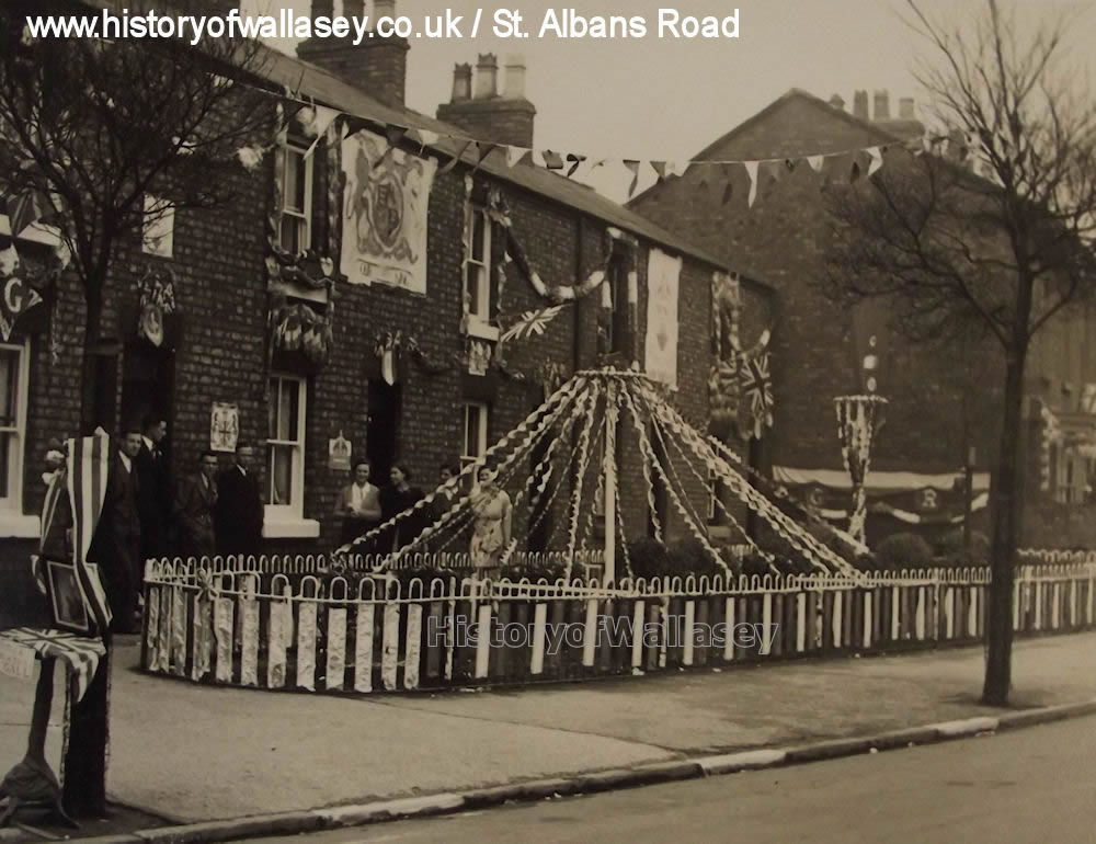
| West View | Group of seven houses located in St. Alban's Road, Liscard. They were all demolished to make way for Dominick House which was built in 1970. [MAP 1954] [IMAGE] [IMAGE] |
| Westland House | |
| Wheatland House | |
| Wheatland View | Row of properties which stood between Geneva Road and Lucerne Road, Wheatland Lane. [MAP 1909] |
| White House | Cottage once located on Chapel Hill Road (then called Birkenhead Road) in Moreton. The thatched cottage was built in 1841 and was demolished between the World Wars. [IMAGE] |
| Whitford Terrace | A row of ten private dwellings that were located off Union Street, Egremont. Flats now occupy the site. [MAP 1898] |
| Willow Bank | Property located off Leasowe Road which stood between two other properties. [MAP 1954] |
| Willow Cottage | |
| Willow Terrace | Two properties on Church Road, Seacombe. Properties appear in 1855 Wallasey Local Board Health Map. Demolished and new housing occupies the site. [MAP 1909] |
| Willows, The | A private house at No.14 Prospect Vale, Wallasey Village [MAP 1954] |
| Windsor Terrace | Five properties near the shore in Tollemache Street [MAP 1909] |
| Winton Terrace | Row of four properties on Comely Bank Road [MAP 1898] |
| Wirral Villas | Six houses (four when originally built, 2 added later) gained by an entry off Wallasey Village near the Farmers Arms. [MAP 1954] |
| Withenfield Cottage | 'The Withens' (No. 165 Withens Lane) used to be called "Withensfield Cottage" and was originally built in about 1830. The cottage has been altered and enlarged, with bay windows added at about the time when the First World War was about to begin. [MAP 1875] |
| Withenfield House | Once stood where the small cul-de-sac called Withenfields is today on Withens Lane. Dates back to the 1850s when CWH Pickering lived there prior to moving to Monte Bello c1860. In the 1870s it was a boarding school for young ladies. Then by 1897 the YWCA provided ladies with a room and meals costing 28/- per week (£1.34). The Christian Alliance for Women and Girls used it as a hostel in the 1920s. The property was demolished in about 1930. [MAP 1875] |
| Withenfield Terrace | A range of four private properties on Withen’s Lane opposite Durban Road which still stand today numbered 155 to 161. [MAP 1875] |
| Withenfield Villa | Private property at 163 Withens Lane. The large house has been known as 'Withensfield Villa', 'Withenscroft' (the stone with this can still be seen in the low front wall) and 'The Manse'. It was called by the later name because it was the manse of the Egremont Presbyterian Church at one time when the Reverend James Goold, M.A, lived there in 1904. [MAP 1875] |
| Withens Place | Four private properties on Withens Lane, opposite Liscard Primary School. [IMAGE] |
| Woodlands, The | See Mansions of Wallasey: 'Vale Park Mansions'
|
| Woodville Terrace | Three properties built in the 1850s in Victoria Road, New Brighton, numbered 8,9 and 10. |
| York Terrace | A row of three private houses facing the River Mersey on Wilson Road, Egremont. Number 1 and 3 were once owned by the brothers Robert and Edward McGeoch, building contractors, who both sat on the Wallasey Local Board. |
| Zig Zag Hall | See Mansions of Wallasey: 'Manor Road & Withens Lane'
|