Wallasey From
1851 to 1914
The Second half of the 19th Century and the first few years of the 20th Century was a period that saw a truly remarkable growth of population and urbanistaion in Wallasey; a period also of consolidation when the fundamental role of Wallasey with its three-fold importance as a residential area, a sea-side resort, and an industrial town, became fully established. As the factors influencing this three-fold development in its incipient stages in the first half of the century has been covered in Wallasey 1831 to 1851 it is therefore the section is best dealt with as brief as possible.
Growth of Population
1851 - 1911
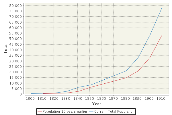 |
From the graph of population above it will be seen that the population of Wallasey increased with great rapidity from 8,329 in 1851 to 78,504 in 1911. This large growth was typical of the north-east corner of the Wirral owing mainly to its proximity to Liverpool.
In 1851, as throughout the century, the greater part of the Wirral retained its rural, agricultural character but in the north-eastern area, comprising Wallasey and Birkenhead, the population density was growing rapidly and the townships concerned were steadily being urbanised. The densities were as follows in 1851 and 1871 :-
| 1851 | 1871 | |
person per 100 acres |
||
| Liscard | 456 | 897 |
| Poulton-cum-Seacombe | 376 | 607 |
| Birkenhead | 2693 | 3280 |
| Tranmere | 609 | 1510 |
| Lower Bebington | 142 | 359 |
| Higher Bebington | 157 | 346 |
| Oxton | 248 | 322 |
| Claughton | 166 | 569 |
| Wallasey | 75 | 122 |
The last five townships lying further to the south and west of the main area affected did not show such a marked increase. Quite clearly then the concentration of population was in the area nearest to Liverpool. In Liverpool itself, growth was proceeding rapidly following upon its development as a port and industrial
In Wallasey, the population grew as show below:-
Year |
Wallasey Township |
Liscard Township |
Poulton-Seacombe Township |
Parish of Wallasey |
Rate of Increase |
| 1851 | 1,195 |
4,100 |
3,044 |
8,339 |
|
| 1861 | 1,415 |
5,625 |
3,683 |
10,723 |
27 |
| 1871 | 1,951 |
8,070 |
4,923 |
14,944 |
39 |
| 1881 | 1,940 |
11,612 |
7,640 |
21,192 |
42 |
| 1891 | 2,067 |
16,323 |
14,839 |
33,229 |
57 |
| 1901 | 4,169 |
28,661 |
20,749 |
53,579 |
61 |
| 1911 | 9,279 |
38,659 |
30,566 |
78,504 |
47 |
From the figures for the Parish, or Borough of Wallasey as it became later, it will be appreciated that between the years 1851 and 1901, the population began to increase rapidly not only absolutely but in the percentage rate of increase. The rate of increase in these five decades was 27%, 39%, 42%, 57% and 61% respectively and few urban areas throughout the country showed higher rates. In the Townships the increase of population naturally was greatest in the two nearest the ferries and Liscard Township, with its two ferries at Egremont and New Brighton and also with a larger area, had a greater population than the Township of Poulton-cum-Seacombe. In Liscard Township moreover the population increased fairly steadily but in Poulton-cum-Seacombe the rate of increase between 1851 and 1881 was so great, possibly owing to the effect on population of the closing down of a number of the industrial works on the margins of Wallasey Pool and the Docks. After this date, however, there was a marked revival of industry involving the establishment of the great flour-milling industry, and the subsequent affect was a great increase in the population of Poulton-cum-Seacombe. In the Township of Wallasey during this period there was a decided lag in growth of population which continued into the early years of the 20th Century. This persisted, owing to the distance from any of the ferries and the inadequate transport facilities until the extension of the Tramway Services to Wallasey Village in 1911.
The Development of
Communications
The remarkable growth of population outlined above was in very large measure the result of the provision of increased and better facilities for traveling to and from Liverpool. Outstanding in this respect was the improvement in the ferry services, but, in addition, there were notable development in railway and road transport facilities.
a) Ferries
The early growth of the ferries at Seacombe, Egremont and New Brighton has already been traced but in the years 1861-1863 an important change took place in respect of the ownership of the ferries. Prior to this date the three ferries had been run by private enterprise but following upon the Wallasey Improvement Act, the ferries at New Brighton and Egremont were purchased by the Wallasey Local Board from Mr. Edward W. Coulbourn at a cost of £60,000 with an additional £9,000 for boats and stores in 1862. During the following year Seacombe Ferry was bought for £30,000 from the Trustees of Admiral Richard Smith. Henceforward, the three ferries were administered by the local authority. From that time at various intervals, improvements and additions were made to each of the ferries. The fleet of steamers, likewise had steadily grown both in regard to the number of boats and in the provision of facilities for carrying a large number of passengers in greater safety and comfort. The chief improvements are indicated under the headings of each ferry.
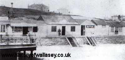
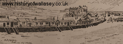
Seacombe Ferry
Here the first notable improvement was made 1876-1880. In 1876, the old ferry with its "run-out gangway" was closed and for three and half years work proceeded on a complete re-construction of Seacombe Ferry and Approach, on which some £147,000 was spent. This work included the reclaimation of land between Seacombe Point and the Old North Reserve Wall (built in connection with the Dock system at an earlier date) on which the now demolished Ferry Hotel and Ferry Approach stand. The re-construction also included the provision of the first floating stage with its gangways and to this was added the hydraulic lift in connection with the luggage-boat service, which remained in use until the floating roadway was opened in 1926. The Clock Tower and associated buildings that remained until re-constructions of 1930-1933 were also built at this time. During this period (1876-1880) a temporary stage was erected against the old North Reserve Wall to function whilst the re-building preceded. In 1903 and again in 1905 further minor improvements were made at a cost of £11,000 and £5,000 respectively.
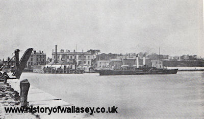 |
Seacombe Ferry, c1876 |
Egremont Ferry
At Egremont between the years 1874 and 1876 a new iron pier was built to replace the older wooden structure. This new pier "terminated in a pair of tripods, connected by an arch, which collectively formed a feature familiar on Merseyside for 35 years. On a stone slip. still existing, a run out stage doubled the extensive length of low water landing worked as was the older one, from the whitewashed engine house south of the pay gays, where also was the 'gridiron' on which boats were repaired".
In this condition the ferry remained until 1909 when a sum of £10,000 was spent on the provision of a new floating stage between dolphins which existed until a further reconstruction in 1929-1930.
 |
Egremont Ferry, c1895 |
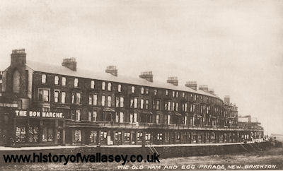
New Brighton Ferry
At New Brighton, the primitive wooden pier erected by James Atherton remained in use until about 1867 when an iron pier and the first floating stage was constructed. With minor alterations in 1901 at an expense of £3,500, this stage and its bridges functioned until structural replacements were made in 1921 and 1928.
Meanwhile, and supplementary to these great improvements in the ferry stages and piers, a gradual evolution towards the capacious and luxurious ferry-boats of today was taking place. Reference has already been in an early part to the primitive wooden, single-mast sailing boats that played early in the century. By the year 1856, the fleet consisted of the 'Tiger', 'Elizabeth', 'Wallasey', and the 'Queen of Beauty' all of which were small paddle boats probably ranging up to some 150 tons. The 'Elizabeth' and the 'Wallasey' were constructed of wood and were the last wooden boats to be used on the passenger service. All four had open decks with the main covered accommodation in the form of cabins below the decks. Their engine-power was very limited and breakdowns were all too frequent.
Additional hindrances to the regularly of service were caused through the use if the ferry boats fir towing purpose. Even so, conditions were considerably improved on those prevailing during the earlier years of the century. The “Gem” which appeared on the service in 1859-1860 showed but little improvement on the existing boats and is mostly noteworthy in connection with the only disaster of importance into the history of the ferries. This occurred on the morning of 26th November, 1878, when the “Gem” in a dense fog, fouled the selling “Bowfell” at anchor in mid-river, with the result that the funnel fell among the 250 passengers causing a panic. Many people were pushed overboard and fifteen lives were lost, even though the vessel was not damaged below the water line, and was in no danger of sinking. The beginnings of saloon accommodation were visible in the “Water Lily”, 1862; the “Heather Bell” 1865, was the first boat with two funnels and also had a double saloon. In 1884 and 1885 respectively the “Crocus” and the “Snowdrop”, the first twin-screw passenger steamers were placed on the service. Each of 300 tons, they had a capacity of 1303 passengers, and in addition to possessing side saloons on deck they had a large smoking cabin below. A few years later, with the arrival of the “Lily” and the “Rose” in 1900, the modern area of screw-built steamers can be said to have been established for, after that date, no more paddle steamers were built.
The natural outcome of all these improvements and in particular, the provision of bigger and faster ferry-boats was the speeding-up of the services and a reduction of the fares. Prior to about 1880, the boats ran from Seacombe every quarter-hour until 9pm when an half hour service was carried on until midnight. After that, late travelers had to cross to Birkenhead and from there either had to use a horse-cab or walk. After that year, however, it was decided to institute a 10 minutes service which in many cases meant that the people working in Liverpool could travel back to Wallasey during the lunch-hour.
The combined effect of all these improvements in the ferry services and the resulting development of Wallasey as a “bedroom” of Liverpool and as a sea-side resort, can be judged by the enormous number of passengers carried annually in the early years of the twentieth century. In 1902, the number totalled some 16½, million people end by 1914 this had increased to 24 million. The income derived from the ferry undertakings amounted to £83,400 in 1902 and had risen to £107,700 in 1914. Unfortunately however, in the latter years the increased expenditure on the provision of better facilities together with the increased costs of maintenance resulted in a debit of £4,470 to the Rates of Wallasey.
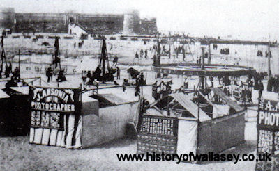
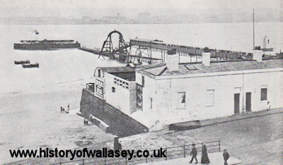
 |
View of New Brighton Promenade from the pier, 1905 |
b). Wallasey Communication
The development of land communications and especially of railways in the Wallasey area was very slow. This can be accounted for partly by the natural isolation of Wallasey from the rest of the Wirral Peninsula and partly by the dependence of Wallasey’s inhabitants on the ferry services to Liverpool. Between 1840 and 1866 several new lines of railway was constructed on the Wirral. In 1866 the Wirral Railway was built from Birkenhead Docks Station to Hoylake. Wallasey however, was ignored until 1886, when, following upon the opening of the Mersey Tunnel Railway with its attention to Birkenhead Park station, a branch line of the Wirral Railway was constructed to New Brighton via Wallasey Village. Shortly afterwards, an additional branch line was extended to Seacombe Ferry from which station a railway was constructed in the years 1888-1895 running through Bidston, Heswall, and across the centre of the Wirral via Heswall Hills, Neston, Connah’s Quay and Shelton to North Wales. The importance of these railways to Wallasey has been limited except in so far as they provided an additional route to Liverpool via the Mersey Railway for the inhabitants of New Brighton and Wallasey Village. In 1903, the Mersey Railway was electrified and this gave some stimulus to the passenger traffic from New Brighton and Wallasey Village but the necessary change at Birkenhead Park from steam to electric trains has always militated against the success of this line,
The existing railway facilities of Wallasey are of very little importance to providing access to other parts of the country outside the Wirral. The services are poor and frequently necessitate changes with considerable delays, accordingly, people travelling to and from Wallasey invariably utilise the main line facilities provided in Liverpool and Birkenhead by the London, Midland and Scottish, and the Great Eastern Railways respectively. There are, of course, exceptions when special day excursion trains are run to Wallasey in the summer season.
c). Road Transport
More important in many respects than the provision of railway communications, was the internal development of road transport in Wallasey. The present-day main roads were mostly in existence by the middle of the nineteenth century. Since then, naturally many of them have widened and modernised to meet the requirements of present-day traffic, but the only new main roads of outstanding importance constructed since 1870 were the following:-
Birkenhead Road and Dock Road, which with the Four Bridges and Duke Street Bridge, were constructed in connection with the building of the Wallasey and Birkenhead Docks. These bridges together with Poulton Bridge provided, for the first time, direct land communication to Birkenhead across Wallasey Pool. The value of these bridges, however, was reduced by the frequent delays by the passage of vessels to and from the Docks. Unfortunately the issue is less problematic with the Docks being less used. Poulton Bridge moreover, was a Toll Bridge but had road approaches on either side and consequently was very little used. It was not until the 1930s that the toll was abolished and the road on either side improved.
Seabank Road was extended from Manor Lane across the fields and Magazine Lane to join Rowson Street, thus providing a through route from New Brighton via Egremont to Seacombe Ferry. Prior to this extension about 1860, the chief way from New Brighton to Seacombe was via Rowson Street, Rake Lane, Liscard Road, and Borough Road, an alternative route was from Montpelier Crescent along Mount Road, turning to the right down Mount Pleasant Road and along Seaview Road (then called Marsden’s Lane), provided the gates which stood at Hose Side Road end were open, it being a private road.
Belvidere Road, running parallel to, and west of Seaview Road, was constructed partly on an accommodated road leading to Littledale’s Model Farm in Mill Lane. From Belvidere Road cross-connections were made with Seaview Road and Claremount Road by Kingsway and Broadway Avenue (formerly Townfield Lane) respectively. These two roads together with Earlston Road provided an east-west route across Wallasey from Rake Lane to Wallasey Village.
Warren Drive, second only in importance to the extension of Seabank Road, was extended in 1880. Until that date, Warren Drive only reached as far as the west end of ‘Stonebark’, but then it was extended to meet Grove Road, thus giving New Brighton quicker access to Wallasey Village and the Leasowe Road outlet to Moreton and north Wirral. Originally, it was intended to carry on the road in a direct line to Belvidere Road, which was to be continued across the farm fields to Mill Lane and then along to link up with Gorsey Lane (then also an accommodation road) and so via Duke Street Bridge and road to Charing Cross, Birkenhead. Unfortunately, this scheme for a through route to Birkenhead was prevented firstly by the opposition of a piece of land about Broadway Avenue, and secondly, through the building of houses in Grove Road, facing the present end of Warren Drive. Later, in the 1930’s, a through route was built on practically the site via Rolleston Drive, Belvidere Road, Torrington Road, Woodstock Road, Oxton Road and Gorsey Lane.
Hose Side Road was made to give access from Grove Road and Warren Drive to the reconstructed Seaview Road.
Harrison Drive opened on 24th June 1901 and provided an extension from the junction of Wallasey Village and Grove Road to the sea-shores.
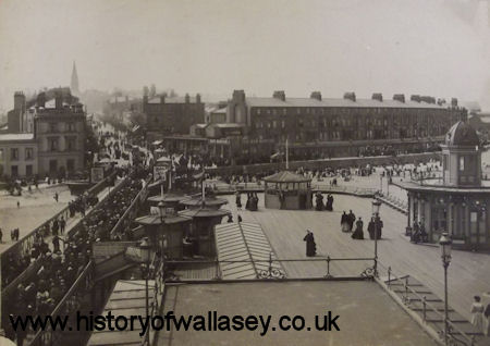
 |
View of Wallasey Village, c1910 |
The net result of these extensions and new road constructions, together with the innumerable small roads built in connection with housing estates, was that the roads and highways under the control of the local authority steadily increased in mileage. This is shown in the following table:-
Miles |
Furlongs |
|
| 1864 | 18 |
6 |
| 1870 | 19 |
2½ |
| 1880 | 23 |
4 |
| 1890 | 30 |
6 |
| 1900 | 36 |
1 |
| 1910 | 56 |
1 |
| 1914 | 65 |
6 |
Closely related to these improvements and extensions of the roads of Wallasey was the development of the Tramway service. These services became more and more urgent as the need arose to provide transport between the ferries and the increasing and scattered settlements of Wallasey. Although the local authority had obtained power to institute Tramways under the Improvement Act of 1867, nothing apparently was done until 1901. Prior to that date certain services had seen undertaken by private enterprise. The proprietor of Seacombe Ferry Hotel ran semi-public vehicles as far as Leasowe Castle, but they would be intended for the use of visitors rather than residents. Later, in 1879, the Wallasey Tramways and Omnibus Co. laid a single track of approximately two and three-quarter miles running from Seacombe Ferry via Liscard Village to Field Road on the higher ground of New Brighton. This undertaking was purchased in 1901 by the Wallasey Urban District Council for £20,500 including the rolling stock of 7 cars, each capable of seating 34 passengers, seventy-eight horses, stables and tram lines. Until 17th March, 1902, this horse-car Tramway was successfully operated when ut was replaced by the first of the electric Tramways. In later years a number of routes were to the public as follows:-
Rake Lane - March, 1902
Seabank Road - March, 1902
Warren Drive - May, 1902
Falkland Road - July, 1907
Poulton Road - July, 1910
Poulton Road to Wallasey Village - February, 1911
These tramway services effectively linked the various parts of Wallasey with one another and with the ferries; particularly important was the 1911 extension to Wallasey Village which paved the way for the subsequent opening up of that area in the post-war years of the Great War. Their success was assured from the outset and the number of passengers carried annually grew with great rapidity as indicated below:-
Year |
Passengers carried in 1000's |
Mileage in 1000's |
Income £ |
Credit to Rates |
| 1903 | 5,685 |
655 |
31,470 |
- |
| 1908 | 8,331 |
891 |
43,820 |
4,340 |
| 1914 | 13,105 |
1,291 |
63,710 |
7,750 |
The Four-Fold Character of Wallasey
During the years 1851 to 1914, Wallasey definitely established itself as a team with the four-fold character:-
1. A “bedroom” of Liverpool;
2. A Sea-side Resort;
3. An Industrial and Commercial Centre;
4. A Market-Gardening Region
The importance of each of these roles varies in relation to one another. Undoubtedly, the prize function of Wallasey is as a residential area and the other three functions, although important, are wholly subsidiary and must remain so by virtue Wallasey’s position in relation to Liverpool. Moreover, those other functions are very definitely localised in the northern, southern and western margins respectively of the older built-up eastern area. The market-gardening too, is almost certain to disappear with the westward expansion of urbanisation.
1). Wallasey, a “Bedroom” of Liverpool
The role of Wallasey as a dormitory of Liverpool had already been indicated in the sections of this part dealing with the growth of population and with the development of communication. Here, it is proposed to indicate briefly the effect of this function on the actual settlement in the area. A valuable indication is provided in the following figures of the growth of rateable value as settlement proceeded:-
Assessable Value £ |
|
| 1845 | 25.000 |
| 1853 | 35,000 |
| 1871 | 74,000 |
| 1881 | 127,000 |
| 1891 | 161,000 |
| 1901 | 325,000 |
| 1911 | 461,000 |
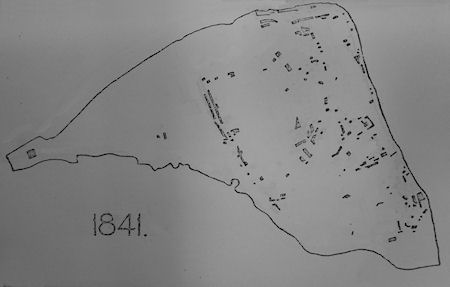
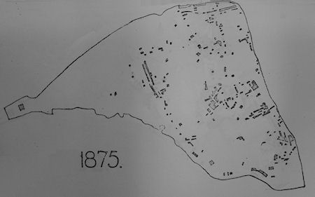
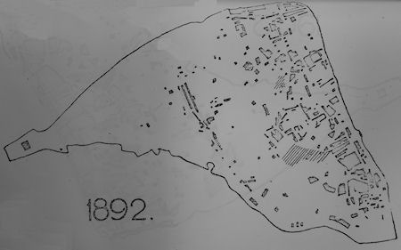
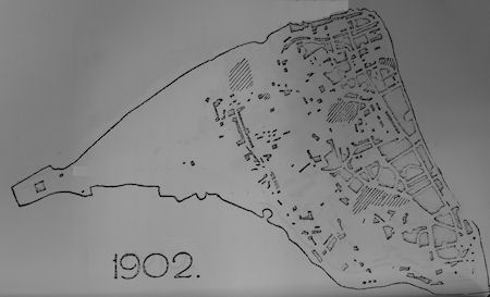
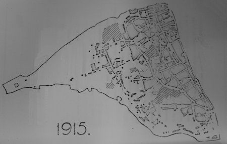
Especially noteworthy among those figures is the doubling of the assessable value in the decade 1891-1901, a period that saw a tremendous growth in the building of houses as is seen by comparing the maps showing the built-up areas. The following series of maps indicate generally the built-up areas at the following dates 1841, 1875, 1892, 1902 and 1915. They were constructed by shading in the built-up portions as indicated on old maps of Wallasey and the Ordnance Maps of Wallasey at the respective additions. It is not claimed that these generalised maps are strictly accurate but they are sufficiently correct to illustrate the main trends of building development. The line-shaded areas indicate public open-spaces.